ilerda
Conservative
Posts: 1,026
|
Post by ilerda on Aug 17, 2021 20:35:39 GMT
 Sorry it's not football-related, but here's an actual fantasy Dearne Valley constituency. And on 2019 numbers it's even in quota! I've said before that I think it's a shame that a lot of theses smaller towns and villages with strong local ties were torn apart and put into much larger metropolitan districts based on towns they have less in common with. This constituency is a little redress to that. |
|
Deleted
Deleted Member
Posts: 0
|
Post by Deleted on Aug 17, 2021 20:41:09 GMT
Why would you use polling districts to sensibly split a ward? Polling districts are the only sensible way to divide wards in England. |
|
|
|
Post by Wisconsin on Aug 17, 2021 21:30:13 GMT
Why would you use polling districts to sensibly split a ward? Polling districts are the only sensible way to divide wards in England. Might as well use a ouija board. |
|
|
|
Post by relique on Aug 17, 2021 21:40:37 GMT
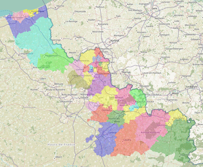
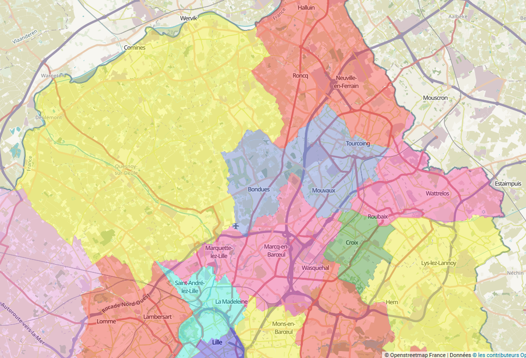
I was wondering what kind of constituencies we could have in my Département if we had as many MPs as in your Commons (or rather as much population per MP).
So in the Nord département, it would yield to 35 constituencies instead of the current 21.
In the Dunkerque arrondissement, the three constituencies would become five.
There would be
- "Dunkerque-Ouest" (pink) with Grande-Synthe and Loon-Plage towns and inside Dunkerque, the 'communes' Saint-Pol-sur-Mer, Fort-Mardyck, Mardyck, Petite Synthe.
- "Dunkerque-Est" (yellow) with Coudekerque-Branche and Leffrinckouke towns with the eastern part of Dunkerque (Dunkerque-Sud, Centre, Rosendaël, Malo) - "Littoral dunkerquois" (dark blue) with notably Gravelines, Bray-Dunes, Capelle-la-Grande, Têteghem-Coudekerque-Village etc..
- "Haut de Flandre" (light blue) around Wormhout, Steenvoorde and Hondschoote and a lot of rural Flandre - "Flandre intérieure" (green) around Hazebrouck, Bailleul and Merville.
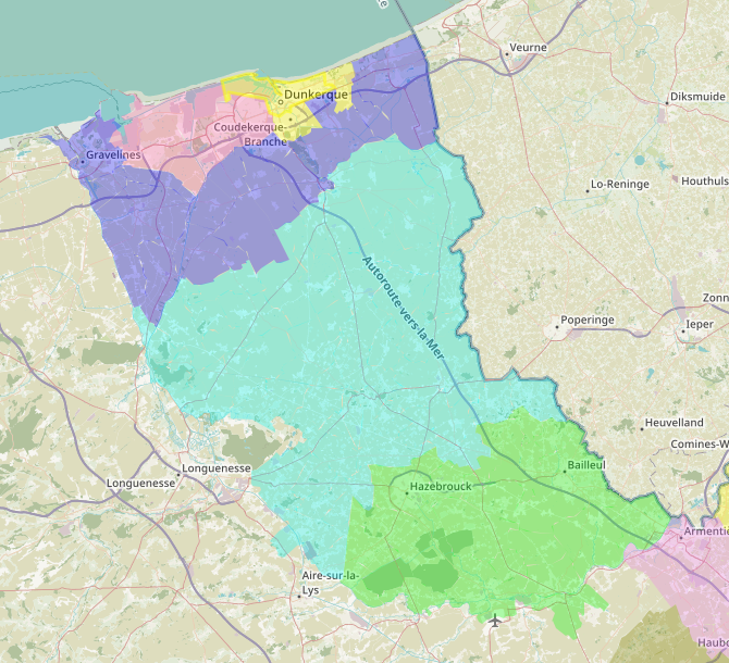
Then, in the Lille arrondissement we would go from 10 to 17 constituencies. In the urban area of Lille:
There would be:
- "Lille-Sud" (pink) with Ronchin, Faches-Thumesnil and Lezennes towns and southern Lille (Lille-Sud, part of Moulins)
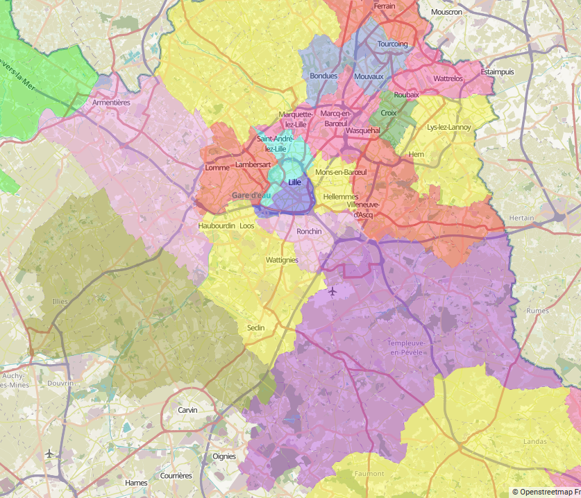
- "Lille-Est" (yellow - center) with Mons-en-Baroeul town and eastern Lille (Hellemmes, Fives and Saint-Maurice-Pellevoisin) - "Lille-Nord" (light blue) with La Madeleine and Saint-André-lez-Lille towns and northern Lille (Vieux-Lille, Vauban-Esquermes) - "Lille-Ouest" (red - west/left) with Lambersart, Sequedin and Lompret towns and western Lille (Lomme, Bois-Blancs) - "Lille-Centre" (dark blue) with inside Lille: Lille-Centre, Wazemmes, Faubourg de Béthune and part of Moulins - "Mélantois" (yellow - south-west/left) with Haubourdin, Loos, Seclin, Wattignies, Templemars, Houplin-Ancoisne, Emmerin, Vendeville and Noyelles-lès-Seclin towns - "Villeneuve-d'Ascq" (red - east/right) with Villeneuve d'Ascq, Baisieux, Chéreng, Anstaing, Tressin and Gruson towns
In the Roubaix and Tourcoing urban area:
With the following constituencies:
- "Tourcoing-Nord" (red) with Halluin, Roncq and Neuville-en-Ferrain towns + northern Tourcoing
- "Tourcoing-Sud" (dark blue) with Mouvaux and Bondues towns + southern Tourcoing - "Roubaix-Wattrelos" (pink - east/right) with Wattrelos town + north-east Roubaix - "Roubaix-Croix" (green) with Croix + west Roubaix - "Roubaix-Hem" (yellow - east/right) with Hem, Lys-lez-Lannoy, Leers, Toufflers, Willems, Sailly-lez-Lannoy, Lannoy and Forest-sur-Marque towns + south-east Roubaix - "Lys et Deûle" (yellow - west/left) with Roncq, Comines, Wambrechies, Linselles, Quesnoy-sur-Deûle, Wervicq-sud, Bousbecque, Verlinghem, Frelinghien and Deûlémont towns - "Deûle et Marque" (pink - center) with Marcq-en-Baroeul, Wasquehal and Marquette-lez-Lille towns
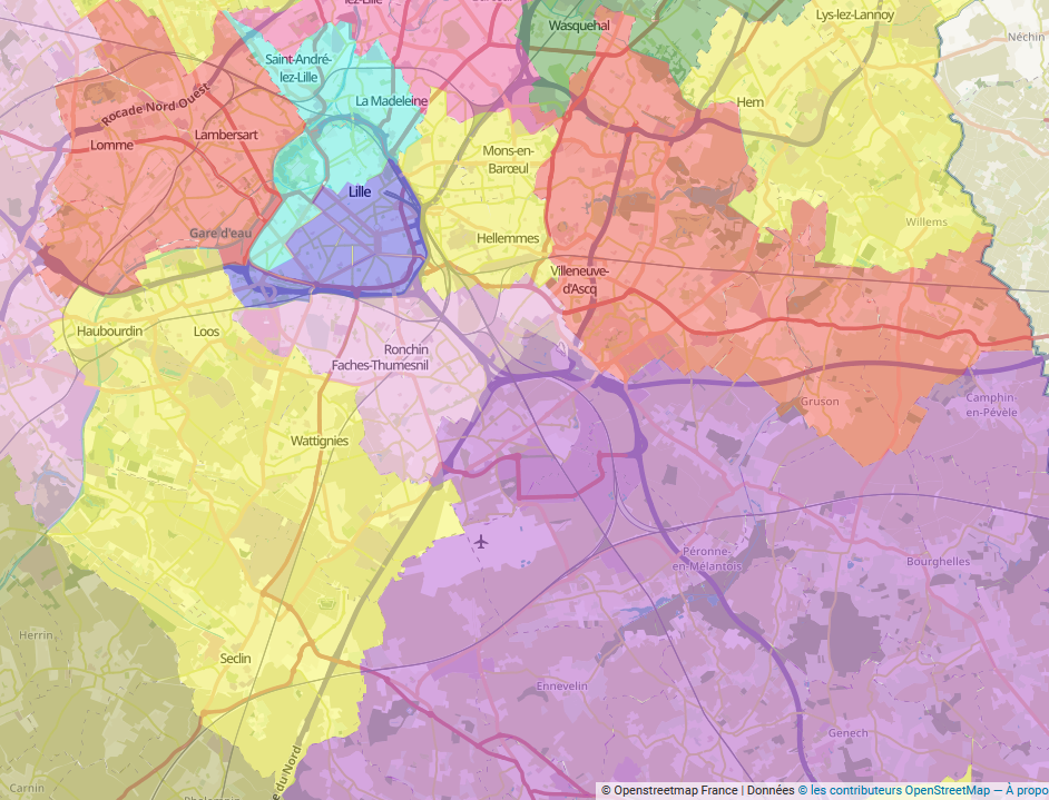
The rest of the Lille arrondissement:
With the remaining three constituencies:
- "Lys et Weppes" (pink - west/left) with Armentières and the neighbouring Houplines and La Chappelle-d'Armentières towns, as well as more rural areas in the Weppes with Santes, Hallennes-lez-Haubourdin, Radinghem-en-Weppes and other towns - "Weppes et Carrembault" (green - west/left) with also some Weppes towns (La Bassée, Wavrin, Sainghin-en-Weppes...) and the Carembault towns (Annoeullin, Phalempin, Bauvin, Provin, Gondecourt...) - "Pévèle et Mélantois" (purple) with the northern parts of the Pévèle (Templeuve-en-Pévèle, Ostricourt, Cysoing, Thumeries, Mérignies, Pont-à-Marcq...) and part of Mélantois (Lesquin, Fretin, Sainghin-en-Mélantois, Avelin...)
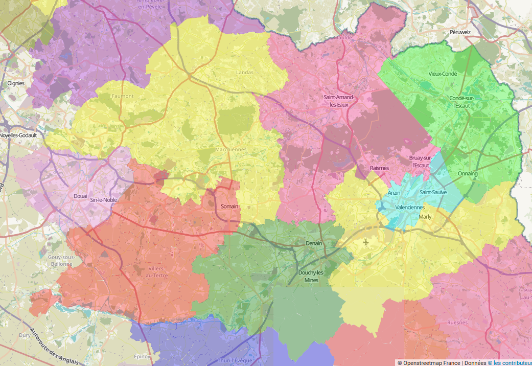
From the Douai and Valenciennes arrondissement there were 5 constituencies and now there would be 8:
There could be:
- "Douai" (light pink - west/left) with Douai, Sin-le-Noble, Waziers, Cuincy, Flers-en-Escrebieux, Lambres-lez-Douai, Courchelettes, Lauwin-Planque and Esquerchin towns - "Ostrevent" (red) with Somain, Aniche, and a lot of other former-mining towns - "Pévèle et Scarpe" (yellow -north-west/left) with, from southern Pévèle: Orchies, Raimbeaucourt, Coutiches and Beuvry-la-Forêt and towns in the Scarpe plain: Auby, Roost-Warendin, Pecquencourt, Flines-lez-Raches, Fenain, Marchiennes... - "Haut-Escaut" (green - south) with notably Denain, Douchy-les-Mines and Escaudain in the Escaut plain.
- "Plaine de la Scarpe" (pink - east/right) with Saint-Amand-les-Eaux, Raismes, Bruay-sur-l'Escaut and Beuvrages towns among others - "Bassin de l'Escaut" (green - east/right) with Vieux-Condé, Condé-sur-l'Escaut, Onnaing, Fresnes-sur-Escaut, Quièvrechain... - "Sud Valenciennois" (yellow - south-east/right) with Marly, Aulnoy-lez-Valenciennes, Trith-Saint-Léger, Petite-Forêt and other towns around Valenciennes - "Valenciennes" (light blue) with Valenciennes, Anzin and Saint-Saulve towns.
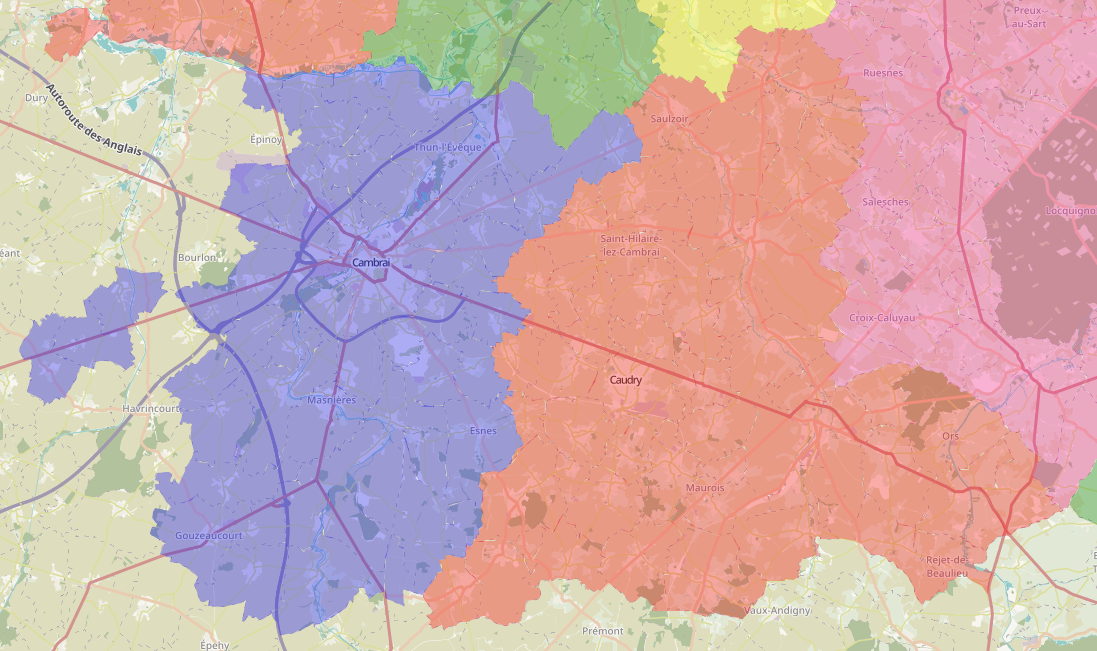
Then, the last two arrondissements, Cambrai and Avesnes, that had only three constituencies would get five, two for Cambrai and three for Avesnes. First, Cambrai:
- "Cambrai" (blue) with Cambrai and the rural parts around it, including the three towns that are inside the Pas-de-Calais département. - "Caudrésis, Catésis et Solesmois" the rural areas around and including the towns of Caudry, Le Cateau-Cambrésis and Solesmes
And finally, the three constituencies in the Avesnes-sur-Helpe arrondissement:
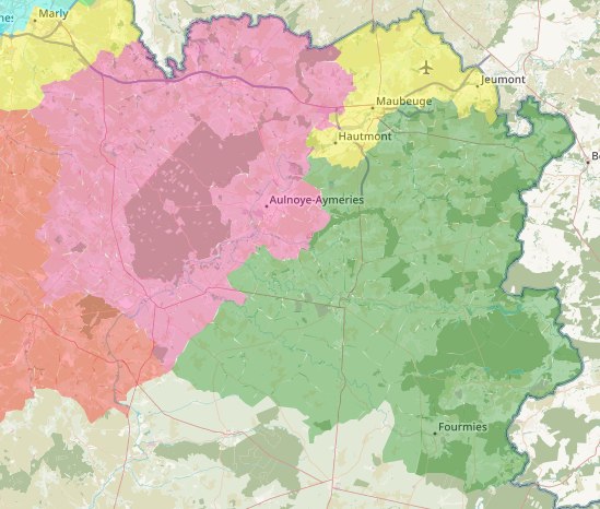
- "Maubeuge" (yellow) with Maubeuge, Hautmont, Jeumont, Louvroil and other more rural towns - "Avesnois" (green) with Fourmies, Ferrière-la-Grande, Avesnes-sur-Helpe and the rural areas
- "Sambre et Selle" (pink) with Aulnoye-Aymeries, Feignies, Le Quesnoy, Landrecies and the rural areas...
If we forget all about Macron, if the current 21 constituencies are more or less 9 left-wing and 7 right-wing and 5 heavily contested, these 35 would be 15 left-wing (including probably 5 or 6 communists), 12 right-wing and 8 heavily contested. The Macron results will be interesting to see at the 2022 presidential because it might not be the same vote as in 2017 (and therefore the same constituencies)
|
|
European Lefty
Labour
Can be bribed with salted liquorice
Posts: 5,515 
|
Post by European Lefty on Aug 17, 2021 21:52:16 GMT
I was wondering what kind of constituencies we could have in my Département if we had as many MPs as in your Commons (or rather as much population per MP).
So in the Nord département, it would yield to 35 constituencies instead of the current 21.
In the Dunkerque arrondissement, the three constituencies would become five.
There would be
- "Dunkerque-Ouest" (pink) with Grande-Synthe and Loon-Plage towns and inside Dunkerque, the 'communes' Saint-Pol-sur-Mer, Fort-Mardyck, Mardyck, Petite Synthe.
- "Dunkerque-Est" (yellow) with Coudekerque-Branche and Leffrinckouke towns with the eastern part of Dunkerque (Dunkerque-Sud, Centre, Rosendaël, Malo) - "Littoral dunkerquois" (dark blue) with notably Gravelines, Bray-Dunes, Capelle-la-Grande, Têteghem-Coudekerque-Village etc..
- "Haut de Flandre" (light blue) around Wormhout, Steenvoorde and Hondschoote and a lot of rural Flandre - "Flandre intérieure" (green) around Hazebrouck, Bailleul and Merville.
Then, in the Lille arrondissement we would go from 10 to 17 constituencies. In the urban area of Lille:
There would be:
- "Lille-Sud" (pink) with Ronchin, Faches-Thumesnil and Lezennes towns and southern Lille (Lille-Sud, part of Moulins)
- "Lille-Est" (yellow - center) with Mons-en-Baroeul town and eastern Lille (Hellemmes, Fives and Saint-Maurice-Pellevoisin) - "Lille-Nord" (light blue) with La Madeleine and Saint-André-lez-Lille towns and northern Lille (Vieux-Lille, Vauban-Esquermes) - "Lille-Ouest" (red - west/left) with Lambersart, Sequedin and Lompret towns and western Lille (Lomme, Bois-Blancs) - "Lille-Centre" (dark blue) with inside Lille: Lille-Centre, Wazemmes, Faubourg de Béthune and part of Moulins - "Mélantois" (yellow - south-west/left) with Haubourdin, Loos, Seclin, Wattignies, Templemars, Houplin-Ancoisne, Emmerin, Vendeville and Noyelles-lès-Seclin towns - "Villeneuve-d'Ascq" (red - east/right) with Villeneuve d'Ascq, Baisieux, Chéreng, Anstaing, Tressin and Gruson towns
In the Roubaix and Tourcoing urban area:
With the following constituencies:
- "Tourcoing-Nord" (red) with Halluin, Roncq and Neuville-en-Ferrain towns + northern Tourcoing
- "Tourcoing-Sud" (dark blue) with Mouvaux and Bondues towns + southern Tourcoing - "Roubaix-Wattrelos" (pink - east/right) with Wattrelos town + north-east Roubaix - "Roubaix-Croix" (green) with Croix + west Roubaix - "Roubaix-Hem" (yellow - east/right) with Hem, Lys-lez-Lannoy, Leers, Toufflers, Willems, Sailly-lez-Lannoy, Lannoy and Forest-sur-Marque towns + south-east Roubaix - "Lys et Deûle" (yellow - west/left) with Roncq, Comines, Wambrechies, Linselles, Quesnoy-sur-Deûle, Wervicq-sud, Bousbecque, Verlinghem, Frelinghien and Deûlémont towns - "Deûle et Marque" (pink - center) with Marcq-en-Baroeul, Wasquehal and Marquette-lez-Lille towns
The rest of the Lille arrondissement:
With the remaining three constituencies:
- "Lys et Weppes" (pink - west/left) with Armentières and the neighbouring Houplines and La Chappelle-d'Armentières towns, as well as more rural areas in the Weppes with Santes, Hallennes-lez-Haubourdin, Radinghem-en-Weppes and other towns - "Weppes et Carrembault" (green - west/left) with also some Weppes towns (La Bassée, Wavrin, Sainghin-en-Weppes...) and the Carembault towns (Annoeullin, Phalempin, Bauvin, Provin, Gondecourt...) - "Pévèle et Mélantois" (purple) with the northern parts of the Pévèle (Templeuve-en-Pévèle, Ostricourt, Cysoing, Thumeries, Mérignies, Pont-à-Marcq...) and part of Mélantois (Lesquin, Fretin, Sainghin-en-Mélantois, Avelin...)
From the Douai and Valenciennes arrondissement there were 5 constituencies and now there would be 8:
There could be:
- "Douai" (light pink - west/left) with Douai, Sin-le-Noble, Waziers, Cuincy, Flers-en-Escrebieux, Lambres-lez-Douai, Courchelettes, Lauwin-Planque and Esquerchin towns - "Ostrevent" (red) with Somain, Aniche, and a lot of other former-mining towns - "Pévèle et Scarpe" (yellow -north-west/left) with, from southern Pévèle: Orchies, Raimbeaucourt, Coutiches and Beuvry-la-Forêt and towns in the Scarpe plain: Auby, Roost-Warendin, Pecquencourt, Flines-lez-Raches, Fenain, Marchiennes... - "Haut-Escaut" (green - south) with notably Denain, Douchy-les-Mines and Escaudain in the Escaut plain.
- "Plaine de la Scarpe" (pink - east/right) with Saint-Amand-les-Eaux, Raismes, Bruay-sur-l'Escaut and Beuvrages towns among others - "Bassin de l'Escaut" (green - east/right) with Vieux-Condé, Condé-sur-l'Escaut, Onnaing, Fresnes-sur-Escaut, Quièvrechain... - "Sud Valenciennois" (yellow - south-east/right) with Marly, Aulnoy-lez-Valenciennes, Trith-Saint-Léger, Petite-Forêt and other towns around Valenciennes - "Valenciennes" (light blue) with Valenciennes, Anzin and Saint-Saulve towns.
Then, the last two arrondissements, Cambrai and Avesnes, that had only three constituencies would get five, two for Cambrai and three for Avesnes. First, Cambrai:
- "Cambrai" (blue) with Cambrai and the rural parts around it, including the three towns that are inside the Pas-de-Calais département. - "Caudrésis, Catésis et Solesmois" the rural areas around and including the towns of Caudry, Le Cateau-Cambrésis and Solesmes
And finally, the three constituencies in the Avesnes-sur-Helpe arrondissement:
- "Maubeuge" (yellow) with Maubeuge, Hautmont, Jeumont, Louvroil and other more rural towns - "Avesnois" (green) with Fourmies, Ferrière-la-Grande, Avesnes-sur-Helpe and the rural areas
- "Sambre et Selle" (pink) with Aulnoye-Aymeries, Feignies, Le Quesnoy, Landrecies and the rural areas...
If we forget all about Macron, if the current 21 constituencies are more or less 9 left-wing and 7 right-wing and 5 heavily contested, these 35 would be 15 left-wing (including probably 5 or 6 communists), 12 right-wing and 8 heavily contested. The Macron results will be interesting to see at the 2022 presidential because it might not be the same vote as in 2017 (and therefore the same constituencies)
How did you make the maps? |
|
|
|
Post by relique on Aug 17, 2021 22:08:54 GMT
How did you make the maps? I used Framacarte and a canvass of the french towns in a json document from this blog: france-geojson.gregoiredavid.fr/ Of course, I had to do quite a few changes for big cities as most of them I cut (and therefore I needed to do myself a few things. It takes a lot of time, and to get a good reading of the population, I have to have an excel file with all the towns, their population (and a few characteristics to help me remember where they are located; about 650 towns in Nord), and a table with the population by constituency (they are all between 66 646 and 85 247 inhabitants, which might be a upper-limit a bit too high with 72 623 inhabitants on average; it had to be done to have constituencies inside only one arrondissement) |
|
|
|
Post by Davıd Boothroyd on Aug 17, 2021 22:17:30 GMT
Let's just remember that Calais and Tournai were both boroughs represented in the English Parliament at one time.
|
|
|
|
Post by relique on Aug 17, 2021 22:31:01 GMT
Let's just remember that Calais and Tournai were both boroughs represented in the English Parliament at one time. Great-Britain still is in the french parliament. Alexandre Holroyd is your MP. You also have two senators, Joëlle Garriaud-Maylam and Olivier Cadic.
|
|
|
|
Post by greenchristian on Aug 17, 2021 22:54:15 GMT
Polling districts are the only sensible way to divide wards in England. Might as well use a ouija board. That's unfair. There are only two sets of sub-ward building blocks available, and postcodes are simply too low a level to make the process accessible to the general public. In some areas it's actually easier to make constituencies that respect community ties with polling districts than it is with wards (Coventry being one). Even in areas where polling districts are really badly suited to help with drawing boundaries and the wards are large enough for ward splits to be worth it, they aren't much worse than the actual wards. Remember that most of the places where wards are large enough for us to consider ward splits are large urban areas where wards frequently cut through the middle of communities.
|
|
YL
Non-Aligned
Either Labour leaning or Lib Dem leaning but not sure which
Posts: 4,286
Member is Online
|
Post by YL on Aug 18, 2021 6:53:52 GMT
Might as well use a ouija board. That's unfair. There are only two sets of sub-ward building blocks available, and postcodes are simply too low a level to make the process accessible to the general public. In some areas it's actually easier to make constituencies that respect community ties with polling districts than it is with wards (Coventry being one). Even in areas where polling districts are really badly suited to help with drawing boundaries and the wards are large enough for ward splits to be worth it, they aren't much worse than the actual wards. Remember that most of the places where wards are large enough for us to consider ward splits are large urban areas where wards frequently cut through the middle of communities.
... and where they're not large urban areas (e.g. the East Riding) the wards generally consist of agglomerations of parishes and each parish tends to be a separate polling district, so you can use the PD data to split along parish boundaries. You do of course have quite a lot of options available when a ward contains 28 separate parishes. |
|
J.G.Harston
Lib Dem
Leave-voting Brexit-supporting Liberal Democrat
Posts: 13,617
|
Post by J.G.Harston on Aug 18, 2021 7:42:35 GMT
Why would you use polling districts to sensibly split a ward? Polling districts rarely sensibly split a ward, they are purely for the administrative convenience of getting to this year's polling station. But, at any one point, they are the only sub-ward datum available above "house". Census enumeration districts and end postcodes, while geographically static over long periods, cross ward boundaries, so aren't suitable as *sub*ward units, as their purpose is completely different. |
|
ilerda
Conservative
Posts: 1,026
|
Post by ilerda on Aug 18, 2021 7:50:41 GMT
Why would you use polling districts to sensibly split a ward? Polling districts rarely sensibly split a ward, they are purely for the administrative convenience of getting to this year's polling station. But, at any one point, they are the only sub-ward datum available above "house". Census enumeration districts and end postcodes, while geographically static over long periods, cross ward boundaries, so aren't suitable as *sub*ward units, as their purpose is completely different. I would disagree with “rarely”. I don’t think the average polling district is necessarily any less sensible than the average ward. Just because they’re designed for administrative convenience it doesn’t mean they can’t also be sensible. They might not be optimal, but they can still be sensible. In Sheffield, for example, I think that a lot of the polling districts do make sense and actually in some cases are a better reflection of a community than the wards they sit in. |
|
J.G.Harston
Lib Dem
Leave-voting Brexit-supporting Liberal Democrat
Posts: 13,617
|
Post by J.G.Harston on Aug 18, 2021 10:56:11 GMT
That's unfair. There are only two sets of sub-ward building blocks available, and postcodes are simply too low a level to make the process accessible to the general public. In some areas it's actually easier to make constituencies that respect community ties with polling districts than it is with wards (Coventry being one). Even in areas where polling districts are really badly suited to help with drawing boundaries and the wards are large enough for ward splits to be worth it, they aren't much worse than the actual wards. Remember that most of the places where wards are large enough for us to consider ward splits are large urban areas where wards frequently cut through the middle of communities.
... and where they're not large urban areas (e.g. the East Riding) the wards generally consist of agglomerations of parishes and each parish tends to be a separate polling district, so you can use the PD data to split along parish boundaries. You do of course have quite a lot of options available when a ward contains 28 separate parishes. I agree that sub-ward parishes are a better sub-ward "accounting" division than polling districts, but in the areas where ward division is a possible requirement there tends to not be sub-ward parishes, either because there are no parishes (urban Sheffield) or because the parishes are bigger than the wards (rural Sheffield, Whitby). and so it's the wards that are sub-units of the parishes, not the other way around. In S&W we have one rural parish that is split between borough wards, the dividing line appears to be a carefully drawn sub-parish line rather than the usual arbitary polling district line. I think I've seen an old map that shows it used to be a parish boundary before two parishes were merged. |
|
J.G.Harston
Lib Dem
Leave-voting Brexit-supporting Liberal Democrat
Posts: 13,617
|
Post by J.G.Harston on Aug 18, 2021 11:17:49 GMT
Polling districts rarely sensibly split a ward, they are purely for the administrative convenience of getting to this year's polling station. But, at any one point, they are the only sub-ward datum available above "house". Census enumeration districts and end postcodes, while geographically static over long periods, cross ward boundaries, so aren't suitable as *sub*ward units, as their purpose is completely different. I would disagree with “rarely”. I don’t think the average polling district is necessarily any less sensible than the average ward. Just because they’re designed for administrative convenience it doesn’t mean they can’t also be sensible. They might not be optimal, but they can still be sensible. In Sheffield, for example, I think that a lot of the polling districts do make sense and actually in some cases are a better reflection of a community than the wards they sit in. That's 'cos people like me drew them up. In some cases, actually me.  |
|
|
|
Post by minionofmidas on Aug 18, 2021 13:40:15 GMT
Polling districts rarely sensibly split a ward, they are purely for the administrative convenience of getting to this year's polling station. But, at any one point, they are the only sub-ward datum available above "house". Census enumeration districts and end postcodes, while geographically static over long periods, cross ward boundaries, so aren't suitable as *sub*ward units, as their purpose is completely different. I would disagree with “rarely”. I don’t think the average polling district is necessarily any less sensible than the average ward. bit of a low bar at times |
|
ilerda
Conservative
Posts: 1,026
|
Post by ilerda on Aug 18, 2021 13:59:09 GMT
I would disagree with “rarely”. I don’t think the average polling district is necessarily any less sensible than the average ward. Just because they’re designed for administrative convenience it doesn’t mean they can’t also be sensible. They might not be optimal, but they can still be sensible. In Sheffield, for example, I think that a lot of the polling districts do make sense and actually in some cases are a better reflection of a community than the wards they sit in. That's 'cos people like me drew them up. In some cases, actually me. Well I must congratulate them/you on a job well done. Perhaps you could hire yourself out to help clear up the miss in other local authorities? |
|
J.G.Harston
Lib Dem
Leave-voting Brexit-supporting Liberal Democrat
Posts: 13,617
|
Post by J.G.Harston on Aug 18, 2021 17:31:35 GMT
That's 'cos people like me drew them up. In some cases, actually me. Well I must congratulate them/you on a job well done. Perhaps you could hire yourself out to help clear up the miss in other local authorities? I need to monetise my skill set. |
|
iang
Lib Dem
Posts: 1,526
|
Post by iang on Aug 19, 2021 9:26:21 GMT
I was wondering what kind of constituencies we could have in my Département if we had as many MPs as in your Commons (or rather as much population per MP).
So in the Nord département, it would yield to 35 constituencies instead of the current 21.
In the Dunkerque arrondissement, the three constituencies would become five.
There would be
- "Dunkerque-Ouest" (pink) with Grande-Synthe and Loon-Plage towns and inside Dunkerque, the 'communes' Saint-Pol-sur-Mer, Fort-Mardyck, Mardyck, Petite Synthe.
- "Dunkerque-Est" (yellow) with Coudekerque-Branche and Leffrinckouke towns with the eastern part of Dunkerque (Dunkerque-Sud, Centre, Rosendaël, Malo) - "Littoral dunkerquois" (dark blue) with notably Gravelines, Bray-Dunes, Capelle-la-Grande, Têteghem-Coudekerque-Village etc..
- "Haut de Flandre" (light blue) around Wormhout, Steenvoorde and Hondschoote and a lot of rural Flandre - "Flandre intérieure" (green) around Hazebrouck, Bailleul and Merville.
Then, in the Lille arrondissement we would go from 10 to 17 constituencies. In the urban area of Lille:
There would be:
- "Lille-Sud" (pink) with Ronchin, Faches-Thumesnil and Lezennes towns and southern Lille (Lille-Sud, part of Moulins)
- "Lille-Est" (yellow - center) with Mons-en-Baroeul town and eastern Lille (Hellemmes, Fives and Saint-Maurice-Pellevoisin) - "Lille-Nord" (light blue) with La Madeleine and Saint-André-lez-Lille towns and northern Lille (Vieux-Lille, Vauban-Esquermes) - "Lille-Ouest" (red - west/left) with Lambersart, Sequedin and Lompret towns and western Lille (Lomme, Bois-Blancs) - "Lille-Centre" (dark blue) with inside Lille: Lille-Centre, Wazemmes, Faubourg de Béthune and part of Moulins - "Mélantois" (yellow - south-west/left) with Haubourdin, Loos, Seclin, Wattignies, Templemars, Houplin-Ancoisne, Emmerin, Vendeville and Noyelles-lès-Seclin towns - "Villeneuve-d'Ascq" (red - east/right) with Villeneuve d'Ascq, Baisieux, Chéreng, Anstaing, Tressin and Gruson towns
In the Roubaix and Tourcoing urban area:
With the following constituencies:
- "Tourcoing-Nord" (red) with Halluin, Roncq and Neuville-en-Ferrain towns + northern Tourcoing
- "Tourcoing-Sud" (dark blue) with Mouvaux and Bondues towns + southern Tourcoing - "Roubaix-Wattrelos" (pink - east/right) with Wattrelos town + north-east Roubaix - "Roubaix-Croix" (green) with Croix + west Roubaix - "Roubaix-Hem" (yellow - east/right) with Hem, Lys-lez-Lannoy, Leers, Toufflers, Willems, Sailly-lez-Lannoy, Lannoy and Forest-sur-Marque towns + south-east Roubaix - "Lys et Deûle" (yellow - west/left) with Roncq, Comines, Wambrechies, Linselles, Quesnoy-sur-Deûle, Wervicq-sud, Bousbecque, Verlinghem, Frelinghien and Deûlémont towns - "Deûle et Marque" (pink - center) with Marcq-en-Baroeul, Wasquehal and Marquette-lez-Lille towns
The rest of the Lille arrondissement:
With the remaining three constituencies:
- "Lys et Weppes" (pink - west/left) with Armentières and the neighbouring Houplines and La Chappelle-d'Armentières towns, as well as more rural areas in the Weppes with Santes, Hallennes-lez-Haubourdin, Radinghem-en-Weppes and other towns - "Weppes et Carrembault" (green - west/left) with also some Weppes towns (La Bassée, Wavrin, Sainghin-en-Weppes...) and the Carembault towns (Annoeullin, Phalempin, Bauvin, Provin, Gondecourt...) - "Pévèle et Mélantois" (purple) with the northern parts of the Pévèle (Templeuve-en-Pévèle, Ostricourt, Cysoing, Thumeries, Mérignies, Pont-à-Marcq...) and part of Mélantois (Lesquin, Fretin, Sainghin-en-Mélantois, Avelin...)
From the Douai and Valenciennes arrondissement there were 5 constituencies and now there would be 8:
There could be:
- "Douai" (light pink - west/left) with Douai, Sin-le-Noble, Waziers, Cuincy, Flers-en-Escrebieux, Lambres-lez-Douai, Courchelettes, Lauwin-Planque and Esquerchin towns - "Ostrevent" (red) with Somain, Aniche, and a lot of other former-mining towns - "Pévèle et Scarpe" (yellow -north-west/left) with, from southern Pévèle: Orchies, Raimbeaucourt, Coutiches and Beuvry-la-Forêt and towns in the Scarpe plain: Auby, Roost-Warendin, Pecquencourt, Flines-lez-Raches, Fenain, Marchiennes... - "Haut-Escaut" (green - south) with notably Denain, Douchy-les-Mines and Escaudain in the Escaut plain.
- "Plaine de la Scarpe" (pink - east/right) with Saint-Amand-les-Eaux, Raismes, Bruay-sur-l'Escaut and Beuvrages towns among others - "Bassin de l'Escaut" (green - east/right) with Vieux-Condé, Condé-sur-l'Escaut, Onnaing, Fresnes-sur-Escaut, Quièvrechain... - "Sud Valenciennois" (yellow - south-east/right) with Marly, Aulnoy-lez-Valenciennes, Trith-Saint-Léger, Petite-Forêt and other towns around Valenciennes - "Valenciennes" (light blue) with Valenciennes, Anzin and Saint-Saulve towns.
Then, the last two arrondissements, Cambrai and Avesnes, that had only three constituencies would get five, two for Cambrai and three for Avesnes. First, Cambrai:
- "Cambrai" (blue) with Cambrai and the rural parts around it, including the three towns that are inside the Pas-de-Calais département. - "Caudrésis, Catésis et Solesmois" the rural areas around and including the towns of Caudry, Le Cateau-Cambrésis and Solesmes
And finally, the three constituencies in the Avesnes-sur-Helpe arrondissement:
- "Maubeuge" (yellow) with Maubeuge, Hautmont, Jeumont, Louvroil and other more rural towns - "Avesnois" (green) with Fourmies, Ferrière-la-Grande, Avesnes-sur-Helpe and the rural areas
- "Sambre et Selle" (pink) with Aulnoye-Aymeries, Feignies, Le Quesnoy, Landrecies and the rural areas...
If we forget all about Macron, if the current 21 constituencies are more or less 9 left-wing and 7 right-wing and 5 heavily contested, these 35 would be 15 left-wing (including probably 5 or 6 communists), 12 right-wing and 8 heavily contested. The Macron results will be interesting to see at the 2022 presidential because it might not be the same vote as in 2017 (and therefore the same constituencies)
Reads like a history of the British Army |
|
|
|
Post by greenchristian on Aug 20, 2021 16:55:10 GMT
Why would you use polling districts to sensibly split a ward? Polling districts rarely sensibly split a ward, they are purely for the administrative convenience of getting to this year's polling station. But, at any one point, they are the only sub-ward datum available above "house". Census enumeration districts and end postcodes, while geographically static over long periods, cross ward boundaries, so aren't suitable as *sub*ward units, as their purpose is completely different. I've never come across an example of a postcode that crosses a ward boundary. I'd be interested to know where this actually happens. |
|
|
|
Post by mattb on Aug 20, 2021 18:17:06 GMT
I've never come across an example of a postcode that crosses a ward boundary. I'd be interested to know where this actually happens. You are kidding, right? There are multiple lowest-level postcodes in Three Rivers that cross not only ward boundaries but also County divisions, and indeed the district boundary (especially but not only with Watford) and in a couple of cases the County and Regional boundary with London (Hillingdon) and one (WD3 5PJ if you want to check) with SE Region (Bucks). I know our boundaries are a muddle but I can't believe Three Rivers is that unusual? |
|