The Bishop
Labour
Down With Factionalism!
Posts: 36,834
|
Post by The Bishop on Jul 10, 2022 10:42:54 GMT
What might the historic reasoning have been for such incredibly convoluted boundaries around Donisthorpe - maybe connected to land ownership?
|
|
|
|
Post by islington on Jul 10, 2022 10:52:00 GMT
Just to add that if we assume, as Schedule M seems to provide, that the Derbys exclaves east of the Measham pocket were treated as part of the South Derbyshire division after 1832, then the main Packington exclave interacts with the boundary between North and South Leics in such a way as to create two exclaves of N Leics having borders only with S Leics and S Derbys.
Judging by the OS map neither exclave had any inhabitants.
|
|
|
|
Post by johnloony on Jul 10, 2022 11:01:42 GMT
More than likely, the Counties (Detached Parts) Act of 1844. If you look at the 1885 map of Derbyshire on Vision of Britain you can see that the simplified borders of the Measham pocket are shown as the red constituency boundaries, although there is still something of a mess on the southern edge, around Appleby Magna, which doesn't show up very well at this scale. However, on the background map many of the smaller enclaves to the east of the main pocket, around Packington and Ravenstone, are still shown as dashed lines. The total mess around Donisthorpe isn't shown in detail but the most messy area seems to be delineated by dashed lines on both sides. The 1868 map is on a less detailed base map, but shows the smaller eastern enclaves as part of Derbyshire, except possibly the northernmost one, which has a green boundary but not a red one. The Donisthorpe mess is, again, not clearly shown. So I think that the simplification happened between 1868 and 1885, and was still quite recent at the latter date. Link snot working |
|
|
|
Post by islington on Jul 10, 2022 11:02:18 GMT
What might the historic reasoning have been for such incredibly convoluted boundaries around Donisthorpe - maybe connected to land ownership? I imagine so. In any case, it's not unique to the UK: here's a plan of the small town of Baarle in the southern Netherlands. Except, of course, strictly speaking much of it isn't Dutch territory at all: there are numerous exclaves of Belgium covering most of the town with a few Dutch counter-exclaves to complete the picture. And this is an international boundary. Maybe it matters less in these days of Schengen and the single currency but it caused chaos in WW1 when Belgium was occupied by the Germans but the Netherlands was neutral.

|
|
|
|
Post by finsobruce on Jul 10, 2022 11:04:48 GMT
What might the historic reasoning have been for such incredibly convoluted boundaries around Donisthorpe - maybe connected to land ownership? I imagine so. In any case, it's not unique to the UK: here's a plan of the small town of Baarle in the southern Netherlands. Except, of course, strictly speaking much of it isn't Dutch territory at all: there are numerous exclaves of Belgium covering most of the town with a few Dutch counter-exclaves to complete the picture. And this is an international boundary. Maybe it matters less in these days of Schengen and the single currency but it caused chaos in WW1 when Belgium was occupied by the Germans but the Netherlands was neutral.
Has anyone written a book about that? (the specific topic, not World War I  ). If they haven't, it's just crying out for it. |
|
|
|
Post by finsobruce on Jul 10, 2022 11:07:03 GMT
If you look at the 1885 map of Derbyshire on Vision of Britain you can see that the simplified borders of the Measham pocket are shown as the red constituency boundaries, although there is still something of a mess on the southern edge, around Appleby Magna, which doesn't show up very well at this scale. However, on the background map many of the smaller enclaves to the east of the main pocket, around Packington and Ravenstone, are still shown as dashed lines. The total mess around Donisthorpe isn't shown in detail but the most messy area seems to be delineated by dashed lines on both sides. The 1868 map is on a less detailed base map, but shows the smaller eastern enclaves as part of Derbyshire, except possibly the northernmost one, which has a green boundary but not a red one. The Donisthorpe mess is, again, not clearly shown. So I think that the simplification happened between 1868 and 1885, and was still quite recent at the latter date. Link snot working Wirks worth ok for me. |
|
|
|
Post by carlton43 on Jul 10, 2022 11:08:42 GMT
|
|
|
|
Post by finsobruce on Jul 10, 2022 11:14:57 GMT
i can see we're going to Hulland back on this one. |
|
|
|
Post by carlton43 on Jul 10, 2022 11:16:37 GMT
i can see we're going to Hulland back on this one. That is the centre of your friend Scunthorpe's position! |
|
|
|
Post by finsobruce on Jul 10, 2022 11:23:07 GMT
i can see we're going to Hulland back on this one. That is the centre of your friend Scunthorpe's position! Do try and stick to the map Mr Fogg, accuracy is a dish but Little Eaton. |
|
|
|
Post by East Anglian Lefty on Jul 10, 2022 16:40:33 GMT
It's been suggested that the county boundaries in that bit of the world were deliberately designed to split up the core Mercian territory (Wednesbury to Repton, more or less) up between as many different counties as possible to minimise their influence. Roughly when were they drawn? Tenth century. In the East Midlands shires were military units created in the aftermath of the reconquest of the Danelaw by the West Saxons. Mercia wasn't conquered by Wessex per se, but after the death of Æthelflæd there was effectively a palace coup which led to its absorption and it's likely there were plenty in Mercia who weren't happy about that, so minimising their ability to exercise authority locally was useful. |
|
|
|
Post by johnloony on Jul 11, 2022 10:00:09 GMT
Part of me wants the Boundary Commission to go to the extreme of equalising electorates across the whole country: each constituency is a combination of whole wards, such that there is the smallest possible difference between the minimum and maximum electorates of the constituencies. Split wards are not allowed, therefore equality has to be achieved by using exclaves and detached bit all over the place to fit them into the quota.
|
|
|
|
Post by bjornhattan on Jul 11, 2022 10:20:05 GMT
Part of me wants the Boundary Commission to go to the extreme of equalising electorates across the whole country: each constituency is a combination of whole wards, such that there is the smallest possible difference between the minimum and maximum electorates of the constituencies. Split wards are not allowed, therefore equality has to be achieved by using exclaves and detached bit all over the place to fit them into the quota. It'd be interesting - but I've studied combinatorics and the sheer number of possibilities (and difficulty of finding a solution) is giving me a headache! |
|
|
|
Post by johnloony on Jul 11, 2022 12:50:49 GMT
Part of me wants the Boundary Commission to go to the extreme of equalising electorates across the whole country: each constituency is a combination of whole wards, such that there is the smallest possible difference between the minimum and maximum electorates of the constituencies. Split wards are not allowed, therefore equality has to be achieved by using exclaves and detached bit all over the place to fit them into the quota. It'd be interesting - but I've studied combinatorics and the sheer number of possibilities (and difficulty of finding a solution) is giving me a headache! The number of combinations would be 650 to the power of however many wards there are. It is a simple matter of going through all the combinations one by one, and finding which one has the smallest range. |
|
pl
Non-Aligned
Posts: 1,568 
|
Post by pl on Jul 11, 2022 13:30:17 GMT
It'd be interesting - but I've studied combinatorics and the sheer number of possibilities (and difficulty of finding a solution) is giving me a headache! The number of combinations would be 650 to the power of however many wards there are. It is a simple matter of going through all the combinations one by one, and finding which one has the smallest range. I hate to break it to you johnloony but the Ancient Athenians beat you to it (in a manner of speaking): en.wikipedia.org/wiki/DemeIn the reforms of Cleisthenes, each "tribe" of Athens was made up of three of the 30 trittyes sub-divisions: one from each of the urban, coastal and inland regions. The aim was to make sure that citizens had exposure to other interest groups than their own, and to make sure that each tribe was not a representative of one specific geographic area. The tribes were important in the structure of the Boule (the Council of 500 which controlled the agenda of the assembly). John's plan would, give or take, do the same thing. |
|
J.G.Harston
Lib Dem
Leave-voting Brexit-supporting Liberal Democrat
Posts: 13,728
|
Post by J.G.Harston on Jul 11, 2022 14:15:24 GMT
It'd be interesting - but I've studied combinatorics and the sheer number of possibilities (and difficulty of finding a solution) is giving me a headache! The number of combinations would be 650 to the power of however many wards there are. It is a simple matter of going through all the combinations one by one, and finding which one has the smallest range. You can use a path searching algorithm to do it much fast.
Oh, but people want to outlaw algorithms....
|
|
|
|
Post by finsobruce on Jul 11, 2022 14:34:27 GMT
The number of combinations would be 650 to the power of however many wards there are. It is a simple matter of going through all the combinations one by one, and finding which one has the smallest range. You can use a path searching algorithm to do it much fast.
Oh, but people want to outlaw algorithms....
is there any sort of calculation as to how much it would cost us to get rid of algorithms? |
|
|
|
Post by greatkingrat on Jul 11, 2022 15:41:16 GMT
Here's an equal Cornwall, I don't think I'll try the whole country though!  |
|
|
|
Post by John Chanin on Jul 11, 2022 15:57:45 GMT
The number of combinations would be 650 to the power of however many wards there are. It is a simple matter of going through all the combinations one by one, and finding which one has the smallest range. You can use a path searching algorithm to do it much fast.
Oh, but people want to outlaw algorithms....
A tailored virus should do the trick. Or an asteroid if you prefer overkill. |
|
|
|
Post by 🏴☠️ Neath West 🏴☠️ on Jul 11, 2022 16:09:14 GMT
Here's an equal Cornwall, I don't think I'll try the whole country though! It's strangely reminiscent of this: 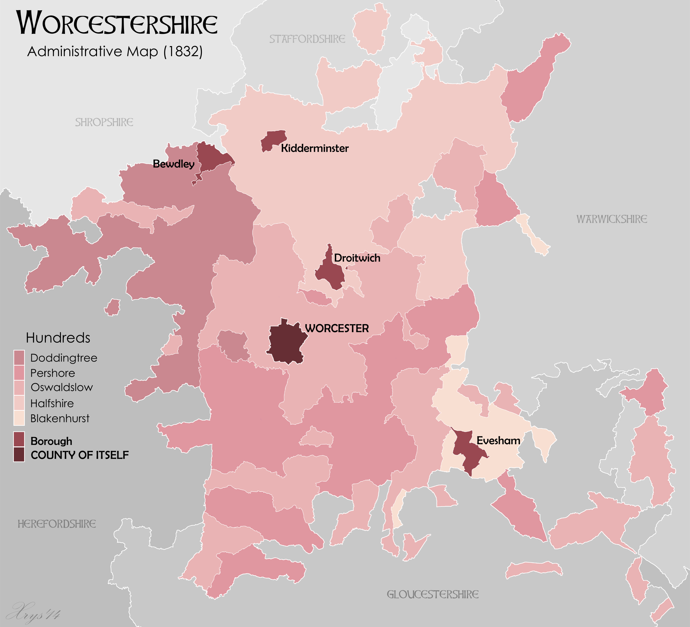 |
|


 ). If they haven't, it's just crying out for it.


