iain
Lib Dem
Posts: 11,451 
|
Post by iain on Jun 28, 2013 10:20:51 GMT
|
|
iain
Lib Dem
Posts: 11,451 
|
Post by iain on Jun 28, 2013 19:24:18 GMT
Also andrewteale, the 2001 Gloucs map on your site is the notional results map, rather than the actual wards
|
|
|
|
Post by andrewteale on Jun 29, 2013 1:26:39 GMT
I'll admit to being confused by that Iain. There is no 2001 Gloucestershire map on LEAP - only 2005 and 2009.
|
|
iain
Lib Dem
Posts: 11,451 
|
Post by iain on Jun 29, 2013 8:27:48 GMT
Apologies, I have no idea how I came to that conclusion :S
|
|
|
|
Post by mick745 on Feb 12, 2014 7:56:06 GMT
I am sorry for not knowing this but where are historic ward/local government maps and parliamentary constituency maps available from? I am interested in any from pre-1970. Thanks
|
|
|
|
Post by Pete Whitehead on Feb 12, 2014 8:35:17 GMT
I certainly did have such a map - I have or had a number of these which I got from the respective county halls in the pre-internet days and I do remember going to Gloucestershire county Hall some time after the 1993 elections. Whether I still have this is another matter and if I do finding it may take some time but I do plan to have a sort out of all this kind of stuff in the near future
|
|
|
|
Post by David Ashforth on Feb 12, 2014 19:51:37 GMT
I am sorry for not knowing this but where are historic ward/local government maps and parliamentary constituency maps available from? I am interested in any from pre-1970. Thanks The Vision of Britain website has historic boundary maps. The maps are a lot older than 1970 so possible not what you're looking for. |
|
|
|
Post by Pete Whitehead on Feb 12, 2014 20:00:16 GMT
|
|
maxque
Non-Aligned
Posts: 9,312 
|
Post by maxque on Feb 13, 2014 2:34:23 GMT
I am sorry for not knowing this but where are historic ward/local government maps and parliamentary constituency maps available from? I am interested in any from pre-1970. Thanks The Vision of Britain website has historic boundary maps. The maps are a lot older than 1970 so possible not what you're looking for. The "election results" section has vague outline maps for every election colored by parties (from 1832 to 2005). It has errors at places, through. |
|
|
|
Post by Pete Whitehead on Feb 14, 2014 14:03:14 GMT
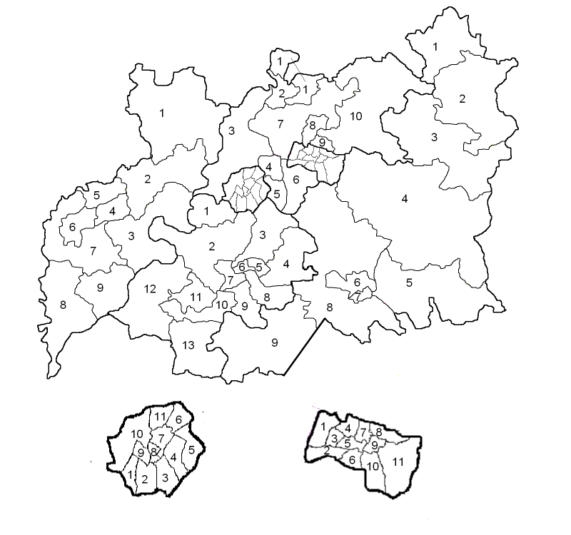
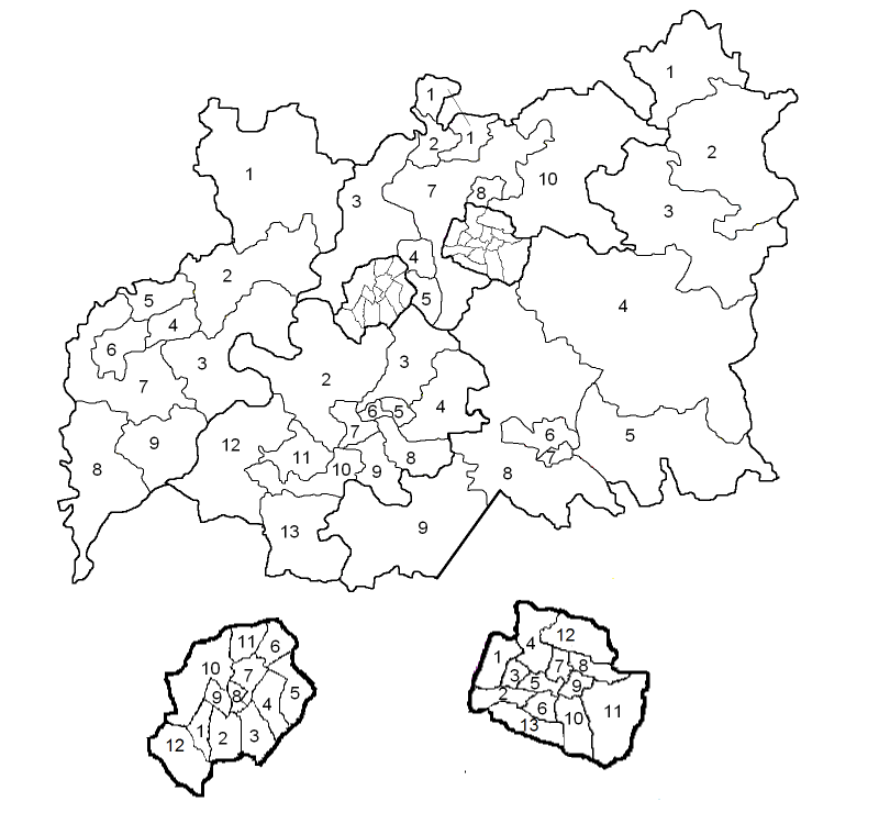
I found myself with a couple of hours to kill late last night and as I had an outline map of the old wards in Gloucestershire I was able to put this together from report I linked to. These are the county boundaries which came into effect before the 1985 elections and were used in that election and that of 1989.  | Forest of Dean | | Tewkesbury | | Cotswold | | Stroud | | | | | | | | | | | | 1 | Newent | 1 | Ashchurch & Twyning | 1 | North Cotswold | 1 | Quedgeley | | 2 | East Dean | 2 | Tewkesbury | 2 | Moreton in Marsh | 2 | Severn | | 3 | Severn Dean | 3 | Severn Vale | 3 | Bourton-Stow | 3 | Painswick | | 4 | Cinderford | 4 | Churchdown | 4 | Northleach | 4 | Bisley | | 5 | Brooksdean | 5 | Brockworth | 5 | East Cotswold | 5 | Stroud E | | 6 | Coleford | 6 | Cotswold Edge | 6 | Cirencester N | 6 | Stroud W | | 7 | West Dean | 7 | Mid Tewkesbury | 7 | Cirencester S | 7 | Stonehouse | | 8 | Tidenham | 8 | Bishop's Cleeve & Swindon | 8 | South Cotswold | 8 | Minchinhampton | | 9 | Lydney | 9 | Prestbury | 9 | Tetbury | 9 | Nailsworth | | | | 10 | Winchcombe | | | 10 | Dursley | | | | | | | | 11 | Cam | | | | | | | | 12 | Berkeley Vale | | | | | | | | 13 | Wotton-Under-Edge |
| Cheltenham | | Gloucester | | | | | | | | 1 | Hesters Way | 1 | Podsmead | | 2 | Hatherley | 2 | Tuffley | | 3 | St Mark's | 3 | Matson | | 4 | St Peter's | 4 | Barnwood | | 5 | Lansdown | 5 | Hucclecote | | 6 | Park | 6 | Longlevens | | 7 | St Paul's | 7 | Eastgate | | 8 | Pittville | 8 | Barton | | 9 | All Saints' | 9 | Linden | | 10 | College | 10 | Westgate | | 11 | Charlton Kings | 11 | Kingsholm |
|
|
|
|
Post by Pete Whitehead on Feb 14, 2014 14:27:09 GMT
The document posted in the opening post refers to the relatively minor(in that they affected a small number of divisions) changes which ocurred prior to the 1993 elections and were consequent upon the expansion of the boroughs of Cheltenham and Gloucster into areas previously within the Tewkesbury and Stroud districts respectively  Changed divisions were as follows: Bishop's Cleeve & Swindon lost Swindon and became Bishop's Cleeve Swindon was joined with the St Peter division of Cheltenham Prestbury division was unchanged but had been moved from Tewkesbury to Cheltenham The Cotswold Edge division of Tewkesbury was abolished with most of its electorate forming the new Leckhampton & Up Hatherley division of Cheltenham (13 on the map above). The wards of Badgeworth and Shurdington were joined to the existing Mid Tewkesbury division Quedgeley ward was annexed to Gloucester and formed a new truncated Quedgeley division (12 on the map above). The Hardwicke ward which had formed part of the previous division was joined with the existing Severn division |
|