|
|
Post by BossMan on Aug 9, 2023 17:36:24 GMT
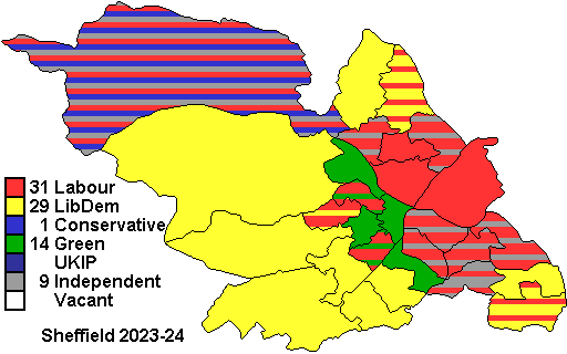
Sheffield
|
|
YL
Non-Aligned
Either Labour leaning or Lib Dem leaning but not sure which
Posts: 4,341
|
Post by YL on Aug 9, 2023 18:26:14 GMT
(Updated 4 October following defections, and again 23 October)
Currently Lab 31, Lib Dem 29, Green 14, Con 1, Ind 9, all the Ind having been elected as Labour. All but one of the Independents are sitting as the “Sheffield Community Councillors Group”.
Defending parties in split wards:
Crookes & Crosspool (2 Lab, 1 Lib Dem): Lab
East Ecclesfield (2 Lib Dem, 1 Lab): Lib Dem
Mosborough (2 Lib Dem, 1 Lab): Lab
Nether Edge & Sharrow (2 Lab, 1 Green): Green
Park & Arbourthorne (2 Lab, 1 Ind): Ind
Stocksbridge & Upper Don (1 Lab, 1 Ind-SCCG, 1 Con): Con
Walkley (2 Lab, 1 Green): Green
plus the wards split only because of the Foxite split:
Birley (2 Ind-SCCG, 1 Lab): Ind-SCCG
Manor Castle (2 Lab, 1 Ind-SCCG): Lab
Richmond (2 Lab, 1 Ind-SCCG): Lab
Shiregreen & Brightside (2 Lab, 1 Ind-SCCG): Lab
Southey (2 Lab, 1 Ind-SCCG): Ind-SCCG
Woodhouse (2 Lab, 1 Ind-SCCG): Lab
|
|
iain
Lib Dem
Posts: 10,789 
|
Post by iain on Aug 10, 2023 11:46:30 GMT
So, can Labour win a majority in Sheffield in 2024? The answer should really be yes, even if the lacklustre results in May 2023 mean that overall control is not the slam dunk it should have been. Labour will feel their goal is within touching distance, though a repeat of those disappointing 2023 results would leave them a couple of seats short. However, if Sheffield’s elections over the past few years have proved anything, it is surely that old adage that past performance is no guarantee of future results.
Parties have gone from sweeping all before them to flirting with disaster in no time at all – most notably last year, when the Lib Dems were forced to defend a number of wards on very tight margins after an appalling performance in 2022, only to hold on everywhere, by record margins in more than a few places. At the moment it appears that the Lib Dems are on the up with the Greens on the way down, but just a few months ago I would have said something very different.
Labour needs a gain of four to get over the top: more than doable, though they themselves have a couple of vulnerable seats they need to defend. A brief ward by ward preview follows – and bearing in mind the rather wild swings over the past few years, I’ve listed majorities from 2021, 2022 and 2023. I have assumed there won't be a General Election on the same day.
To start, Labour defences:
Barring something totally unforseen, 9 of their 11 defences will be held: Birley, Burngreave, Darnall, Firth Park, Manor Castle, Richmond, Shiregreen & Brightside, Southey and Woodhouse
Mosborough: 4.5%, 2.9%, 5.9%
The Lib Dems have won this 5 of the past 6 times it has been up for election, but never particularly emphatically. Incumbent Tony Downing is very popular (he easily outran his alphabetically advantaged running mates in the 2016 all ups), and should be favoured if he restands. If he steps down, expect the result on a knife edge.
Crookes & Crosspool: 4.4%, 3.0%, 2.8%
Incredibly competitive over the past decade and a half, neither Labour nor the Lib Dems has managed to hold a full slate here since the first coalition-affected election in 2011. The Lib Dems expected to finally retake the last seat in 2021 but were in line for a rude awakening from voters, and the same went for Labour in 2023. Labour will expect to hold on this time, absent another of their periodic local meltdowns, but this one is always a bunfight.
And now, the much longer section on non-Labour defences.
Park & Arbourthorne: 21.4%, 26.4%, 31.3%
A nice easy start. Labour will easily regain this seat from a defector. I don't expect Sophie Wilson to restand, but even if she does she will struggle to break 5%.
Stocksbridge & Upper Don: 8.8%, 3.0%, 17.0%
The site of much Tory excitement a few years ago, their first councillor in more than a decade looks odds on to lose in 2024. The Lib Dems could, maybe even should, win here, but in this ward that requires a good local candidate, as well as capacity from the campaign team. I haven't seen any signs that we are going for it, so Labour should win the final seat relatively comfortably.
Walkley: 8.0%, 1.7%, 18.3%
After long threatening to gain this seat, the Greens finally managed it in 2021. Since then they appear to have fallen apart spectacularly, and the new Labour group leader (who narrowly held the ward in 2022) has been credited with a turnaround in the larger party's fortunes here. I have a suspicion Bernard Little will stand down, and Labour will be confident of retaking the seat here.
Nether Edge & Sharrow: 14.2%, 8.0%, 10.0%
Ground zero of the tree protests, after the council took legal action against then-Green councillor Alison Teal, this looked for a while like becoming a relatively safe seat. However when she stood down in 2022 Labour gained the ward easily, adding another gain in 2023. The reason for this rather abrupt about-turn in the ward's voting patterns are a bit of a mystery, but one would assume (possibly foolishly) that they will continue, and Labour will win back the final seat.
East Ecclesfield: 0.4%, 8.1%, 2.6%
After a couple of Lib Dem gains on very low voteshares, Labour looked to have stopped the rot in 2022, holding their final seat comfortably. The Lib Dem hold in 2023, with by far their highest vote since the coalition, came as a surprise, and 2024 will most likely be another very tight contest.
Graves Park: 9.0%, 1.6%, 4.4%
Long one of the safest Lib Dem seats, this has become a battleground in the last couple of years after Labour almost gained it in a shock (including to themselves) in 2022. I expect the longstanding and popular Ian Auckland to stand down after his wife did last year, but I still suspect this one is a little safer than it looks. If I were Labour I'd look elsewhere for gains.
Hillsborough: 5.8%, 6.5%, 7.6%
Even as the Greens have begun to falter elsewhere in the city, they have pushed ahead in Hillsborough, gaining the final councillor in 2023 by the largest margin yet. I'd expect them to hold on, but Labour may have other ideas. This should remain a close contest.
Gleadless Valley: 9.9%, 10.3%, 7.9%
Nothing sums up Sheffield Labour's (and more specifically the hapless Heeley CLP's) malaise better than allowing this to become one of the Green's safest wards in the city. In fairness it has all the ingredients for a high Green base vote, but also those for a Labour vote well in excess of any challenger. If Labour pull themselves together then this should be the obvious candidate for a gain from further back. I suspect the Greens will hold it comfortably enough.
Ecclesall: 8.6%, 4.6%, 8.6%
Traditionally a safe Lib Dem ward, it will have voted Labour at the past two general elections, and has become a Lib Dem-Green fight locally. If I were in charge of the Green campaign this year I would (temporarily) abandon the campaign here to focus on consolidation in a tough year, but I suspect they'll fight on. Even if they do I expect the Lib Dems will hold, but wouldn't be shocked by a loss. Either way, with the Labour vote well squeezed in 2023, Ecclesall will not be relevant to the main event.
Beauchief & Greenhill: 0.7%, 3.7%, 14.6%
An incredibly socially divided ward destined to remain a marginal in perpetuity, the Lib Dems have nevertheless always come out on top here, barring the routs of 2012 and 2015. It was almost a shock loss in 2021, but just two years later recorded that party's highest ever voteshare. One would assume that the Lib Dems will hold the seat once again.
West Ecclesfield: 7.9%, 7.5%, 15.1%
Since the Lib Dems won this back from Labour in 2018, they have won every year, solidly but unspectacularly. I don't see any reason for this to change in 2024, as Labour will have other priorities.
Beighton: 1.0%, 2.1%, 15.3%
Gained for the first time post-coalition, the Lib Dems rode their luck here for several years, gaining all three seats on low voteshares and by small margins. Then, in 2023, they held the seat first gained in 2019 by a huge margin with a new candidate. What happened? I have no idea. I'd now guess that this will be held, but a reversion to a close race which could go either way certainly can't be ruled out.
Broomhill & Sharrow Vale: 1.3%, 7.0%, 17.8%
A close result out of nowhere in 2021, Labour will no doubt think they are still in with a chance here. I'd be surprised to see it fall this time around, but note that the 2023 result hugely flatters the Greens as last minute shenanigans around the Labour candidate plunged the challenging campaign into chaos a matter of weeks before the election.
City: 19.0%, 23.8%, 23.5%
A fairly solidly Green seat, only usually lost in general election years. They did lose a seat to Labour in the 2016 all ups, and regained it by just 16 votes in 2018, but since then it has settled back into the usual pattern. There is obvious Labour potential here, but this is very unlikely to be a priority.
Fulwood: 24.7%, 11.4%, 24.6%
The site of an extremely energetic Labour campaign for the past two years, this nontheless remains a safe Lib Dem seat. That the ward was so close in 2022 came as a major shock, but the Lib Dem vote recovered to usual levels in 2023, even as Labour's held up rather well. The only thing really worth watching here will be the extent to which it uselessly sucks up the time of Labour volunteers.
Stannington: 2.7%, 8.2%, 28.9%
Always Lib Dem but frequently close, the yellows recorded their worst ever voteshare in the ward in 2021, but their best ever in 2023. The extreme volatility makes this unpredictable, but given they have never actually lost the ward, and attentions are likely to be elsewhere, this should be a Lib Dem hold.
Dore & Totley: 22.0%, 30.7%, 38.7%
The Tories challenged here not so long ago, but aren't even in second any more. A mega safe Lib Dem seat.
|
|
|
|
Post by Price of dawn on Aug 10, 2023 11:57:41 GMT
I'm fairly confident. P&A should be back in the Labour column. Walkley has a pretty stonking Labour vote now. I would guess CC, EE and Mosborough would continue to be split with incumbents benefiting. Stockbridge I think will be a gain but maybe with reduced majority.
|
|
The Bishop
Labour
Down With Factionalism!
Posts: 36,657
|
Post by The Bishop on Aug 10, 2023 12:59:51 GMT
Maybe the change in council leadership might help a bit too, some may feel they have had their pound of flesh over the trees issue.
|
|
Chris from Brum
Lib Dem
What I need is a strong drink and a peer group.
Posts: 9,204
|
Post by Chris from Brum on Aug 10, 2023 13:53:31 GMT
So not many direct LD/Green contests? I wonder if either party might try to shut the other out at the cost of Labour holding on in some seats.
|
|
YL
Non-Aligned
Either Labour leaning or Lib Dem leaning but not sure which
Posts: 4,341
|
Post by YL on Aug 10, 2023 15:12:59 GMT
Central-Hillsborough
This is the city centre, the inner western suburbs around the University of Sheffield, and stretching north-west to Hillsborough. This area has become a Green/Labour battleground, with this year the Greens defending all four seats. In 2023 the Greens won three seats and Labour one.
Broomhill & Sharrow Vale (3 Green)
Broomhill is a middle-class Victorian suburb (described by John Betjeman as "the prettiest suburb in England") which now has a large student population. The rest of the ward also has a large student population, and includes the Botanical Gardens and the surrounding area, trendy Sharrow Vale and inner city Broomhall, which includes a 1960s council estate which contrasts with the Victorian housing in the rest of the ward. Large parts of the University of Sheffield campus are in this ward, as is the Collegiate Crescent campus of Sheffield Hallam University; it also contains the Royal Hallamshire Hospital.
The demographics below show the effects of the high student population; the non-student population of Broomhill, Sharrow Vale and the Botanical Gardens area is mostly middle class and well educated, but Broomhall has an ethnically mixed working class population, with a notable Somali element which has provided several of the ward's recent councillors.
Political history: There's been a Broomhill ward of some sort since 1929, and it was a safe Conservative ward until the 1980s, when it became a Lab/Con marginal for a time before settling down to voting Lib Dem in the late 1990s. It used to extend further out into what is now Fulwood ward than this version, and Sharrow Vale was only added in 2016. The 2004 to 2016 incarnation was Lib Dem pre-Coalition but Labour took it in 2011 and 2012; the Greens moved into second place in 2012 and then won it in both 2014 and 2015. Under the new boundaries in 2016 Labour won two seats and the Greens one, but the Greens took the Labour seats in 2018 and 2021 and now have all three.
2021 Census: Managerial and professional 27.6% (17/28), routine and semi-routine 9.1% (26/28), students 46.5% (2/28), never worked/long term unemployed 4.9% (23/28), owner occupied 34.9% (26/28), social rented 15.4% (17/28), private rented 49.1% (2/28), level 4 qualifications 43.9% (7/28), no qualifications 6.3% (26/28), no religion 54.1% (1/28), Christian 25.8% (26/28), Muslim 9.0% (9/28)
City (3 Green)
This ward contains the City Centre, which, like many city centres, has a lot of modern apartment developments, and indeed the ward has the highest proportion of households being flats of any ward in Yorkshire and the Humber. It includes the city centre campus of Sheffield Hallam University and parts of the University of Sheffield campus, and a lot of the flats are aimed at students and many of the others are inhabited mostly by recent graduates; the unusual demographics of the ward reflect this. It has the second highest proportion of ethnically Chinese residents of any ward in England and Wales, after Deansgate in Manchester.
The ward extends outside the Inner Ring Road in two places. One is Kelham Island, an area with a long industrial heritage, and containing Sheffield's main industrial museum. The "island", which is actually rather smaller than the area it gives its name to, is between the River Don and a goit (mill race) which diverts water from the Don for water power. The area contains more student accommodation and modern flats, but also real ale pubs, breweries and restaurants, and increasingly also some upmarket private housing developments.
On the other side of the City Centre, the ward also includes part of Highfield, which has many Victorian terraces, and includes Bramall Lane football ground. This area is convenient for Sheffield Hallam University and so it shares the high student population of the rest of the ward.
Political history: This is the successor to the 2004 to 2016 Central ward, which generally voted Green except in 2004 (when it split three ways, electing one each of Lab, Green and Lib Dem) and when there's been a simultaneous General Election, when it has voted Labour. In 2016, cut down to not much more than the city centre, Labour won one seat and the Greens the other two; the Greens then took the Labour seat with a small majority in 2018 and have held all three since then, with this ward having the highest Green share in the city in 2023. Before 2004, there wouldn't be an obvious predecessor to the current ward: bits were in Sharrow (usually Labour), Castle (always Labour) and Netherthorpe (often Labour, but usually Lib Dem from the mid 1990s onwards).
2021 Census: Managerial and professional 19.7% (22/28), routine and semi-routine 7.4% (28/28), students 61.3% (1/28), never worked/long term unemployed 3.4% (27/28), owner occupied 16.5% (28/28), social rented 11.2% (23/28), private rented 71.8% (1/28), level 4 qualifications 47.3% (6/28), no qualifications 5.2% (28/28), no religion 53.3% (2/28), Christian 19.8% (28/28), Muslim 10.0% (8/28)
Hillsborough (3 Green)
Hillsborough is, of course, best known for its football stadium, which was originally known as Owlerton Stadium (hence the club's nickname) and was in the former Owlerton ward rather than Hillsborough ward until 2004. Hillsborough has a substantial suburban shopping area along Middlewood Road and a large park between those shops and the stadium. It is well connected to the city centre and the University area by tram, attracting some people who work in those areas to live here.
Much of the area is terraced housing close to the shops along Middlewood Road and Hillsborough Park. There are some more upmarket pockets, particularly in the north of the ward in the Marlcliffe area, and also some council estates, in particular the inter-war cottage estate of Wisewood in the west and the 1960s maisonettes of Winn Gardens close to Middlewood tram terminus. There's also a large and distinctive block of 1930s private flats called Regent Court, and since the 2016 boundary changes the ward has included a lot of industrial land along the floor of the Don valley stretching towards the city centre and including some modern apartment developments.
Political history: There's been a Hillsborough ward since the area was added to the city at the beginning of the 20th century. For much of that time it actually had a Conservative lean by Sheffield standards, and only really became safe Labour in the 1980s. It then went Lib Dem in the 1990s and back to Labour from 2002 onwards. For many years it voted Labour except in 2007 and 2008, when the closure of Wisewood School was a major issue and it voted Lib Dem, but it has now turned to the Greens and they have all three seats here.
2021 Census: Managerial and professional 33.7% (8/28), routine and semi-routine 25.7% (17/28), students 6.2% (15/28), never worked/long term unemployed 6.8% (19/28), owner occupied 63.2% (14/28), social rented 14.5% (19/28), private rented 22.1% (7/28), level 4 qualifications 34.8% (11/28), no qualifications 16.9% (18/28), no religion 50.4% (6/28), Christian 40.8% (15/28), Muslim 2.4% (21/28)
Walkley (2 Lab, 1 Green; Green defending)
Walkley is a very hilly area north-west of Sheffield city centre, with a lot of Victorian terraces on steep streets. It tends to get more upmarket and less deprived as you go west up the hills; some of the lower areas in the east of Walkley were slum clearance areas where more modern council housing has replaced the terraces. There are also a few areas of Victorian Land Society development, with slightly larger houses and big gardens. The higher parts of Walkley with surviving Victorian housing are quite gentrified, with an educated professional population.
Between Walkley and the city centre, the ward also includes Upperthorpe and Netherthorpe. These were also areas of Victorian terraces, but of a lower quality than most of Walkley (including substantial areas of three room back to backs), and most of these were demolished in the slum clearance era. As a result these areas are now dominated by modern council housing of various types and have a working class demographic, similar to the slum clearance areas in Walkley. Netherthorpe, which is close to the University of Sheffield, also has a lot of purpose built student accommodation.
Political history: There has been a Walkley ward for a long time, since at least 1901. Before the 1990s it was generally a Labour voting area, though like some other areas it did vote Conservative a couple of times in the 1960s. In the 1990s, it became a Labour/Lib Dem marginal, voting Lib Dem more often than not. After major boundary changes in 2004, it continued as a Lib Dem leaning marginal until 2010; after 2010 it became solid Labour for a bit, but has now become a Labour/Green marginal, with the Greens winning for the first time in 2021, but Labour holding on narrowly in 2022 and more comfortably in 2023. J.G.Harston was a councillor here from 1999 to 2010.
2021 Census: Managerial and professional 30.0% (13/28), routine and semi-routine 18.3% (21/28), students 22.2% (4/28), never worked/long term unemployed 10.2% (10/28), owner occupied 43.7% (23/28), social rented 25.7% (11/28), private rented 30.0% (4/28), level 4 qualifications 43.6% (8/28), no qualifications 16.0% (20/28), no religion 45.3% (15/28), Christian 30.9% (23/28), Muslim 13.9% (5/28)
|
|
YL
Non-Aligned
Either Labour leaning or Lib Dem leaning but not sure which
Posts: 4,341
|
Post by YL on Aug 10, 2023 15:14:01 GMT
Hallam
This is the outer west of the city, bordering the Peak District. This is the most Lib Dem part of the city, and they are defending three seats and Labour one. In 2023 they won all four seats.
Crookes & Crosspool (2 Lab, 1 Lib Dem; Lab defending)
This ward is on the hills to the west of the University of Sheffield and Royal Hallamshire Hospital, and many of the people who live in it either work or study there; there is quite a high student population in parts of Crookes and the ward has the highest proportion of people working in education of any ward in Yorkshire and the Humber and is not far off for health. Crookes is mainly Victorian/Edwardian terraced housing, while Crosspool and Sandygate to the west are mostly interwar suburbia.
Like the rest of the Hallam constituency, this is a generally middle class area with low deprivation and high education levels, but there are fewer really upmarket areas here and more private rented housing. One of its polling stations is Hallam FC's Sandygate ground, which for some definitions of "football ground" is the oldest football ground in the world.
Political history: This ward (just called Crookes before 2016, but the boundary changes were minor) was really a 2004 creation, and was safe Lib Dem pre-Coalition. A huge swing saw it go Labour in 2011, and it has since been a close fought Labour/Lib Dem marginal. In 2016 Labour won two seats and the Lib Dems one; in the tree-affected 2018 and 2019 elections, the Lib Dems first took one of the Labour seats before holding their own seat, and in 2019 the Greens nearly beat Labour into third. Labour then recovered, holding the third seat in 2021 and taking another back in 2022, but no party seems able to take a monopoly here and the Lib Dems held their remaining seat in 2023. Before 2004, the largest part of the ward was in the old Hallam ward, which was consistently Conservative until their 1994 collapse and consistently Lib Dem thereafter. On the post-2004 boundaries, which would have been less favourable for them anyway, the Tories have fallen to fourth.
2021 Census: Managerial and professional 45.1% (4/28), routine and semi-routine 10.8% (24/28), students 21.0% (6/28), never worked/long term unemployed 4.0% (25/28), owner occupied 66.5% (11/28), social rented 5.8% (26/28), private rented 27.5% (5/28), level 4 qualifications 53.8% (2/28), no qualifications 6.8% (24/28), no religion 51.3% (4/28), Christian 36.1% (20/28), Muslim 3.8% (14/28)
Dore & Totley (3 Lib Dem)
Dore and Totley are one time Derbyshire villages annexed by the city in the 1930s, and this is the southernmost of the wards in the Sheffield Hallam constituency. Dore has a reputation for being decidedly posh, Totley a bit less so but still mostly middle class. The ward also contains middle class suburban Bradway to the south, while across the Limb Brook to the north and thus always in both Sheffield and Yorkshire, it includes Whirlow, another upmarket area, the tiny village of Ringinglow and some of the western fringes of Ecclesall for which there was no room in the ward of that name. It also includes some rural Peak District fringe and moorlands.
Political history: This was once the Tory stronghold you'd expect. The old Dore ward (which covered a similar area) was consistently Tory until 1994; after then it's usually voted Lib Dem but unlike anywhere in Sheffield still elected Tories occasionally, in 1996, 2000 and 2004. In recent years the Lib Dems have been very comfortable, getting their highest vote share in the city here in 2023. The Tories have still usually been second, unlike in Ecclesall or Fulwood, though in 2023 Labour beat them into third.
2021 Census: Managerial and professional 52.9% (2/28), routine and semi-routine 11.5% (23/28), students 5.7% (18/28), never worked/long term unemployed 4.9% (23/28), owner occupied 84.4% (2/28), social rented 7.3% (25/28), private rented 8.1% (28/28), level 4 qualifications 51.7% (3/28), no qualifications 9.8% (23/28), no religion 41.2% (25/28), Christian 47.7% (4/28), Muslim 3.2% (18/28)
Ecclesall (3 Lib Dem)
Ecclesall is a very middle class area in south-west Sheffield. The ward extends to include some neighbouring areas such as Greystones, Carter Knowle and Millhouses, all of which were part of the old township of Ecclesall Bierlow, one of the six divisions of the ancient parish of Sheffield, which also extended in towards the city centre. Most of it consists of interwar suburbia, with some older housing in and around Greystones and also some more modern areas.
Some areas are very wealthy, some merely comfortable: almost everywhere in the ward is in a Super Output Area in the least deprived 10% in England, and the proportion of adults in managerial and professional jobs is the highest of any ward in Yorkshire and the Humber, as is the proportion of adults with degrees.
Political history: There's been an Ecclesall ward since forever, although if you go back far enough most of the area of the current ward was rural and the votes mostly in areas closer to the city centre. Until 1994 it was generally a Conservative fortress, but they lost it in their collapse that year and it then turned into a Lib Dem fortress. Labour moved into second during the Coalition years, but they didn't really threaten to win. However, in 2019 the Greens have moved into second and in 2022 the ward looked like three-way marginal with between the Lib Dems, the Greens and Labour; in 2023 the Lib Dems recovered a bit to hold on comfortably enough. The once dominant Tories have been fourth in recent years.
2021 Census: Managerial and professional 58.2% (1/28), routine and semi-routine 9.6% (25/28), students 7.3% (12/28), never worked/long term unemployed 3.8% (26/28), owner occupied 87.7% (1/28), social rented 2.0% (28/28), private rented 10.2% (24/28), level 4 qualifications 62.2% (1/28), no qualifications 6.8% (25/28), no religion 46.5% (9/28), Christian 38.8% (17/28), Muslim 6.5% (12/28)
Fulwood (3 Lib Dem)
This is another middle class suburban ward in the west of the city, separated from Ecclesall by the parks and woodland of the Porter Valley. Fulwood proper is a wealthy suburban area just north of the Porter. Further in, Ranmoor and Endcliffe are areas of big Victorian villas built by those who made their money from steel; they also have some big University accommodation complexes, which gives this ward a high student population.
Up on the hill north of Fulwood, Lodge Moor is slightly less upmarket than the rest of the ward, and the ward also contains a large but thinly populated rural area, in the Mayfield Valley and Hallam Moors. As with the rest of Hallam, deprivation is generally very low. It has two "number one in Yorkshire and the Humber" scores: for professional occupations and for people working in healthcare.
Political history: Before 2004, most of this was in the old Hallam ward which had a similar political history to Ecclesall, Conservative before 1994 and Lib Dem thereafter. Since the new Fulwood ward was created in 2004, it's been consistently Lib Dem; various parties have come second, with Labour, who have given the ward a bit of a go, taking that place in 2023.
2021 Census: Managerial and professional 46.1% (3/28), routine and semi-routine 7.6% (27/28), students 27.0% (3/28), never worked/long term unemployed 3.1% (28/28), owner occupied 80.4% (3/28), social rented 5.6% (26/28), private rented 13.6% (14/28), level 4 qualifications 50.9% (4/28), no qualifications 5.5% (27/28), no religion 45.3% (15/28), Christian 40.9% (14/28), Muslim 3.3% (16/28)
|
|
YL
Non-Aligned
Either Labour leaning or Lib Dem leaning but not sure which
Posts: 4,341
|
Post by YL on Aug 10, 2023 15:15:06 GMT
Norton-Sheaf Valley
These wards stretch south from the city centre towards the Derbyshire boundary near Dronfield. The Lib Dems and Greens are defending two seats each here. In 2023 the Lib Dems won two seats and the Greens and Labour one each.
Beauchief & Greenhill (3 Lib Dem)
This ward consists of areas in the south-west of the city, almost all of which were in Derbyshire before annexation by the city in the 1930s. Beauchief (pronounced "Beechiff") is the name of an ancient abbey near the River Sheaf surrounded by woodland, parkland and a golf course, and also refers to a nearby middle class suburban area. Greenhill (pronounced "Grennel" by some, though as spelt by others) is a one-time village swallowed by 20th century urban expansion, and is a bit more mixed, with some middle class areas but also some council housing.
As well as the two areas mentioned in its name, the ward extends southwards to include Jordanthorpe, Batemoor and Lowedges. These are postwar council estates built on the southern edge of the city, and they are one of the most deprived parts of the city, which when combined with Beauchief makes for a very polarised ward.
Political history: There was a ward called Beauchief from 1967 to 2004, which was safe Conservative until the early 1990s when it jumped to being safe Lib Dem. However it included less of the fringe estates than the current ward. The 2004 to 2016 incarnation usually voted Lib Dem, but became very close after 2010, and voted Labour in 2012 and 2015. Under slightly modified boundaries since 2016 it has consistently voted Lib Dem, but majorities over Labour have sometimes been small.
2021 Census: Managerial and professional 30.7% (11/28), routine and semi-routine 27.9% (13/28), students 6.0% (17/28), never worked/long term unemployed 10.0% (13/28), owner occupied 55.6% (16/28), social rented 34.5% (6/28), private rented 9.6% (25/28), level 4 qualifications 31.8% (13/28), no qualifications 18.9% (16/28), no religion 45.9% (11/28), Christian 43.7% (10/28), Muslim 3.8% (14/28)
Gleadless Valley (3 Green)
The name refers to the valley of the Meers Brook, the old Yorkshire/Derbyshire boundary, and the ward contains areas on both sides of the valley and with a mixture of demographic profiles. Meersbrook itself, mainly on the Derbyshire side, is dominated by a park with good views over the city; this is a fairly middle class and well educated area with a bit of an "alternative" reputation. On the Yorkshire side we have the terraced houses of Heeley and Olive Grove, or at least those which are left after large parts of the area were demolished for a never-built road scheme.
Further up the valley is the Council's 1950s Gleadless Valley estate, which was a showpiece development when it was built and has quite an interesting layout to cope with the gradients, but it is now one of the more deprived parts of the city. It includes the two (once three) tower blocks on the top of the hill at Herdings which can be seen from many parts of the city.
Political history: This ward was a 2004 creation. Before then, the most natural comparison would be to Heeley ward, which was Labour in the 1970s and 1980s but voted Lib Dem in most elections from 1994 onwards. Gleadless Valley was often very close in its early years but only actually voted Lib Dem in 2007 and 2008; it then turned solidly Labour. However, the presence of Meersbrook ensures a significant Green vote, the highest outside Central constituency, and after coming close in 2018 the Greens won the ward for the first time in 2019 and followed this up with further gains in 2021 and 2022 so now have all three seats.
2021 Census: Managerial and professional 29.1% (16/28), routine and semi-routine 28.3% (10/28), students 7.2% (13/28), never worked/long term unemployed 11.0% (8/28), owner occupied 50.6% (19/28), social rented 31.8% (8/28), private rented 17.3% (10/28), level 4 qualifications 34.5% (12/28), no qualifications 20.8% (13/28), no religion 51.9% (3/28), Christian 33.6% (22/28), Muslim 6.6% (11/28)
Graves Park (3 Lib Dem)
By most criteria Sheffield's most middle class ward outside Hallam constituency, this ward is named after a large park in the southern suburbs which was in turn named after J. G. Graves, a major benefactor to Sheffield and Lord Mayor in the 1920s. It contains Woodseats and Norton Lees to the north of the park and Norton proper to the south. Almost the entire ward is historically speaking in Derbyshire, Woodseats being added to Sheffield at the beginning of the 20th century and Norton in the 1930s. Woodseats is dominated by pre-WW1 terraces, and much of the rest of the ward is inter-war semis and similar housing.
As mentioned this is generally a middle class ward, without the fringe estates which make its neighbours more polarised, and for an urban area deprivation is mostly fairly low; Norton Lees and Norton are generally a bit better off than Woodseats.
Political history: This is one of those wards which was created in 2004 and doesn't have an obvious predecessor. There was a Norton ward from 1980 to 2004, which usually voted Labour but voted Lib Dem from 1996 to 2000, but it wasn't that similar to this ward. If you go further back most of the area was in consistently Conservative Norton and Woodseats wards before 1967. Graves Park has always voted Lib Dem, though majorities have sometimes been small; the majority in 2022 over Labour was just 90.
2021 Census: Managerial and professional 41.3% (5/28), routine and semi-routine 19.9% (20/28), students 5.1% (22/28), never worked/long term unemployed 5.9% (22/28), owner occupied 75.8% (4/28), social rented 7.9% (24/28), private rented 16.1% (11/28), level 4 qualifications 40.9% (9/28), no qualifications 14.0% (22/28), no religion 47.7% (8/28), Christian 43.2% (12/28), Muslim 3.2% (18/28)
Nether Edge & Sharrow (2 Lab, 1 Green; Green defending)
Nether Edge, including the adjacent Brincliffe area, is a Victorian leafy (meaning that the trees issue was particularly salient here) suburb between the Porter and Sheaf valleys. It has a lot of stone villas, but also some areas of smaller terraced housing, especially in the east towards Abbeydale Road, where there is a large Asian community. Some parts, especially in Brincliffe, are really quite upmarket, and have very high education levels; locally over 70% have degrees.
Sharrow is a very ethnically diverse inner city area with a mix of Victorian terraces and some more modern council housing; it merges into Nether Edge in the south. The ward also contains part of Highfield, which is similar to Sharrow; both it and Highfield have high student populations.
Political history: Until 2004 there were separate Nether Edge and Sharrow wards, covering areas outside as well as inside this new ward. Nether Edge was a Conservative stronghold until going Labour in 1984, after which it never went Tory again but became a Lib Dem ward in the 1990s; the 2004 to 2016 version was Lib Dem pre-Coalition and Labour from 2011 onwards, though note a very strong Green second place in 2015. Sharrow sometimes voted Conservative in the distant past, but from 1970 onwards was solid Labour; in 2004 Sharrow became part of Central ward which usually voted Green. In the 2016 all-ups, the new ward elected two Labour councillors and one Green; one of the Labour councillors resigned in 2017 over the trees issue and Labour narrowly held the seat over the Greens in the by-election, but then Green councillor and tree campaigner Alison Teal held her seat with a large majority in 2018; the Greens then took the remaining seats in 2019 and 2021, but when Alison Teal retired in 2022 Labour took one seat back and they then took another back in 2023.
2021 Census: Managerial and professional 34.3% (7/28), routine and semi-routine 14.1% (22/28), students 21.5% (5/28), never worked/long term unemployed 10.3% (9/28), owner occupied 47.5% (21/28), social rented 13.9% (20/28), private rented 37.9% (3/28), level 4 qualifications 47.4% (5/28), no qualifications 14.2% (21/28), no religion 41.9% (23/28), Christian 23.6% (27/28), Muslim 24.7% (3/28)
|
|
YL
Non-Aligned
Either Labour leaning or Lib Dem leaning but not sure which
Posts: 4,341
|
Post by YL on Aug 10, 2023 15:16:10 GMT
(Updated 23 October 2023)
Mosborough-Woodhouse
These are outlying areas in the south-east of the city and adjoining the Rother valley.
Labour are defending two seats here and the Lib Dems one, with the fourth being held by an ex-Labour Independent. Labour and the Lib Dems won two each in 2023.
Beighton (3 Lib Dem)
In the and 1960s Sheffield was struggling to find enough land for new housing to replace slums. One option which was considered was to expand Gainsborough in Lincolnshire as a New Town, but eventually, in the late 1960s, an area on the edge of the urban area was annexed from Derbyshire and a substantial New Town style development was built here, now connected to central Sheffield by tram. This development was known as the Mosborough Townships, and contains a number of separate sub-areas (the "townships"). The area was deliberately built with a mixture of tenures and as a result is quite socially mixed.
Beighton ward covers the northern part of the Mosborough Townships area, and includes Owlthorpe, Beighton proper (an old mining village), Sothall and parts of Hackenthorpe; the last named had already had some suburban development before the annexation. There's quite a bit of modern private detached housing, some council estates, especially towards Hackenthorpe, and some older terraced housing in Beighton proper. One of the tram stops is called Donetsk Way, referencing that city's Soviet-era twinning with Sheffield, and some of the platform signs have had Ukrainian flag stickers applied.
Political history: Until 2004, most of this area was part of a giant Mosborough ward. That ward elected an Independent in 1967 and a Tory in 1968, but after that was consistently Labour. From the split until 2019, Beighton ward had also been consistently Labour, though it's shown more signs of a Tory vote than most other Sheffield wards (and they probably carried it in the 2019 General Election). UKIP also did quite well at times. Labour won all three seats in 2016, with a UKIP candidate next behind them, but more recently the Lib Dems have taken over the challenge to Labour here; they won their first seat in 2019 and now have all three. The Lib Dem gains were all quite narrow, but their hold in 2023 was more comfortable.
2021 Census: Managerial and professional 29.8% (14/28), routine and semi-routine 28.1% (11/28), students 4.4% (27/28), never worked/long term unemployed 7.1% (18/28), owner occupied 73.8% (9/28), social rented 14.9% (18/28), private rented 10.9% (20/28), level 4 qualifications 24.4% (20/28), no qualifications 20.8% (13/28), no religion 45.7% (12/28), Christian 47.0% (6/28), Muslim 0.9% (24/28)
Birley (2 Ind-SCCG, 1 Lab; Ind-SCCG defending)
As well as Birley, this ward contains Charnock, Base Green, Frecheville and parts of Hackenthorpe. These areas were annexed from Derbyshire at the same time as the Mosborough Townships, but this area was already more absorbed into the Sheffield urban area than Beighton or Mosborough. Charnock and Frecheville are largely private interwar areas with a lot of semi detached housing and have fairly low deprivation; the rest of the ward is mostly postwar council estates, some of which have had poor quality 1960s housing demolished recently, and deprivation is higher here. Overall the ward has a working class demographic and levels of higher education are noticeably low.
Political history: A similar Birley ward existed from 1967 to 2004, and was usually Labour except in their nadirs of 1968 and 1999, when it voted Tory and Lib Dem respectively. The 2004 to 2016 version always voted Labour, and that has continued since 2016 under slightly modified boundaries; again there was often a significant UKIP vote and it is now the Conservatives who are second, though in 2023 this was a very distant second. Two of the three Labour councillors, including Bryan Lodge of tree infamy, left Labour in October 2023 together with former council leader Terry Fox.
2021 Census: Managerial and professional 24.3% (19/28), routine and semi-routine 31.4% (7/28), students 5.0% (25/28), never worked/long term unemployed 8.8% (14/28), owner occupied 65.8% (12/28), social rented 22.6% (13/28), private rented 10.5% (23/28), level 4 qualifications 20.5% (23/28), no qualifications 23.7% (10/28), no religion 49.7% (7/28), Christian 43.4% (11/28), Muslim 0.8% (26/28)
Mosborough (2 Lib Dem, 1 Lab; Lab defending)
This is the southern part of the Mosborough Townships area (see Beighton), covering Mosborough village itself, a Derbyshire mining village annexed by the city in the late 1960s, and the "townships" of Waterthorpe, Westfield and Halfway; some wag decided that the last of these should be a tram terminus. Like Beighton it is a mix of private detached housing, modern council estates, and some older housing in Mosborough village. It is also demographically similar to Beighton.
Political history: Since the old Mosborough ward was split in 2004, this ward had usually voted Labour, except for a double vacancy election in 2008 when it elected two Lib Dems. More recently, like the rest of the south-east of the city, it had some relatively high UKIP votes, but they hadn't really threatened to win. Then, in a bit of a surprise, there was a by-election in September 2016 in which one of the Lib Dems who had been elected in 2008 stood again and won, giving the Lib Dems their only seat in the east of the city; since then she has won again in 2018 and 2022, the Lib Dems took another seat in 2019, which they then held in 2023, but Labour held one in 2021. As with Beighton it seems likely that the Tories carried it in the General Election.
2021 Census: Managerial and professional 30.7% (11/28), routine and semi-routine 27.3% (15/28), students 4.9% (25/28), never worked/long term unemployed 8.3% (15/28), owner occupied 69.8% (10/28), social rented 18.8% (14/28), private rented 10.9% (23/28), level 4 qualifications 25.5% (18/28), no qualifications 21.2% (12/28), no religion 45.6% (14/28), Christian 47.0% (6/28), Muslim 1.0% (23/28)
Woodhouse (2 Lab, 1 Ind-SCCG; Lab defending)
Woodhouse is an old village east of Sheffield which has now merged into the eastern edge of the urban area, and extends to the Rotherham border at Woodhouse Mill near Woodhouse station. The ward also includes most of neighbouring Handsworth, also a former village which has merged into the city, and which once gave its name to an Urban District which also included Woodhouse, Intake and Richmond.
Both Woodhouse and Handsworth are mixed but largely working class suburban areas, though Handsworth and the area close to Woodhouse station are generally better off than the rest of Woodhouse.
Political history: This largely corresponds to the pre-2004 Handsworth ward. That ward was one of those places which was almost always Labour but voted Conservative in 1967 and 1968; it stayed Labour in the 1990s. Since 2004, Woodhouse has consistently voted Labour, though as in a few places UKIP came close in 2014 and had some other strong results since. In 2023 the Conservatives were a distant second. One of the Labour councillors, Paul Wood (elected 2022), left the party in October 2023 to join Terry Fox's group.
2021 Census: Managerial and professional 25.1% (18/28), routine and semi-routine 30.8% (8/28), students 5.3% (19/28), never worked/long term unemployed 10.1% (12/28), owner occupied 61.1% (15/28), social rented 26.5% (9/28), private rented 11.7% (16/28), level 4 qualifications 23.1% (21/28), no qualifications 23.9% (9/28), no religion 43.8% (18/28), Christian 45.2% (8/28), Muslim 4.8% (13/28)
|
|
YL
Non-Aligned
Either Labour leaning or Lib Dem leaning but not sure which
Posts: 4,341
|
Post by YL on Aug 10, 2023 15:17:30 GMT
(Updated 4 October 2023)
Park-Attercliffe
These four wards are east of the city centre, stretching south from the Lower Don Valley. This is a strongly Labour part of the city, and they are defending three of the four seats here, with the fourth being held by an ex-Labour Independent. Labour won all seats in 2023.
Darnall (3 Lab)
This ward contains Darnall, Tinsley and Attercliffe, including much of the old steel-making heartland of the Lower Don Valley. Its main residential areas, maining in Darnall itself and Tinsley, are working class areas with a lot of terraced housing, some modern council housing, and a high Asian population; the ward is (just) majority Muslim. Much of the housing in the rest of the ward was demolished under slum clearance programmes in the 1960s and 1970s and these areas have a very low residential population. Some areas close to the southern border, the Sheffield Parkway, are more associated with areas to the south such as Handsworth, and this shows in their demographics. It also includes the MeadowhellMeadowhall shopping centre.
Political history: Darnall, Attercliffe and Tinsley all had their own wards in the days before slum clearance, but since 1980 most of this area has been in a single Darnall ward. Wins for parties other than Labour have been rare, but the Lib Dems did win Darnall in 1999, and the Tories in 1968. In recent years Darnall has always voted Labour, and in 2023 it had the highest Labour share in the city.
2021 Census: Managerial and professional 14.0% (28/28), routine and semi-routine 29.7% (9/28), students 10.1% (9/28), never worked/long term unemployed 21.5% (2/28), owner occupied 51.3% (17/28), social rented 26.4% (10/28), private rented 21.8% (8/28), level 4 qualifications 19.9% (26/28), no qualifications 34.3% (1/28), no religion 16.4% (27/28), Christian 27.3% (25/28), Muslim 50.4% (1/28)
Manor Castle (2 Lab, 1 Ind-SCCG; Lab defending)
The name here comes from Sheffield Manor Lodge, home for a time to Mary Queen of Scots; there is not that much left except for a relatively small building known as the Turret House. What's left is sometimes known as the "Manor Castle" and there is a nearby pub of this name. That gives one explanation for the extra word in the name; another is that it comes from the merger of Manor and Castle wards in 2004, but the site of Sheffield's actual Castle, which Castle ward was named for, is not in this ward.
In the 1920s, an area south of the Manor remains was developed as a substantial council estate, known simply as "the Manor" and which has often had a bit of a reputation in the rest of the city; this was later extended northwards, and the ward also includes the originally similar estate of Wybourn. Closer to the city centre was an area of Victorian housing; part of this survives, as a small leafy area of Victorian villas around Norfolk Road, but another part was, before the Second World War, one of Sheffield's worst slum areas. This was redeveloped in the mid 20th century, most famously by the construction of the enormous Brutalist blocks of Park Hill, now a listed building.
Park Hill is currently undergoing a drawn out refurbishment programme with many of the flats being sold, leading to a younger and rather more middle class population moving in, and some being converted to student accommodation; in some ways Park Hill's demographics now look more like those of parts of the city centre than those of the rest of the ward. There are also a couple of more middle class pockets showing in the census figures in areas of the original Manor estate which have been recently redeveloped; the original houses in these areas had structural problems and have been demolished.
Political history: Much of this ward has been in a Labour-voting ward consistently since the 1920s. Before 2004, there were separate Manor (covering the Manor estate) and Castle (covering Wybourn, Park Hill and part of the city centre, including the site of Sheffield Castle) wards, which were basically merged with a few areas being removed. Both were utterly safe Labour fortresses, held comfortably even in 1968 and 1999, and since 2004 Manor Castle has continued in that vein. However former council leader Terry Fox left Labour in October 2023 and is currently sitting as an Independent; his seat is up in 2026.
2021 Census: Managerial and professional 18.9% (23/28), routine and semi-routine 33.0% (4/28), students 12.4% (7/28), never worked/long term unemployed 14.8% (4/28), owner occupied 33.4% (27/28), social rented 47.2% (1/28), private rented 18.7% (9/28), level 4 qualifications 26.2% (16/28), no qualifications 27.7% (5/28), no religion 43.4% (19/28), Christian 37.0% (19/28), Muslim 11.3% (7/28)
Park & Arbourthorne (2 Lab, 1 Ind ex Lab; Ind defending)
The hilly area south-east of Sheffield city centre was once a deer park associated with Sheffield Castle and the Manor Lodge, and as a result became known as Sheffield Park, from 1918 until 1983 giving its name to a whole constituency. This ward roughly covers the south-western half of the Park; most of the rest is in Manor Castle ward. Close to the city centre a substantial open space remains, and was given by a 19th century Duke of Norfolk to the city and hence is known as Norfolk Park. This is partially surrounded by an area, also known as Norfolk Park, which was developed in the 1960s with a large number of tower blocks, and then redeveloped more recently with low rise housing, the tower blocks being blown up.
To the south-east of Norfolk Park is Arbourthorne, a large inter-war council estate, and south again is Gleadless, which has a rather quiet suburban feel with a lot of interwar semis and unlike most of the rest of the ward is less deprived than the English median. Arbourthorne is particularly deprived, but the redevelopment of Norfolk Park has led to a more mixed population here with census areas immediately west of the Park having a more middle class demographic.
Political history: The ward covering most of this area was called Park before 2004 and Arbourthorne between 2004 and 2016. After the 1920s, Park was generally safe Labour (held in 1968) but it voted Lib Dem in 1999 and 2000; the 2004 to 2016 Arbourthorne always voted Labour, and the name change hasn't changed that. Some of Labour's winning shares in recent years have been unimpressive, but the opposition has been so split that no-one else has threatened to win. The councillor elected in 2021 for Labour, Sophie Wilson, has left the party and has been sitting as an Independent, but this was due to dissatisfaction with the national party and I believe unconnected with the Foxite split.
2021 Census: Managerial and professional 21.8% (21/28), routine and semi-routine 33.0% (4/28), students 7.5% (11/28), never worked/long term unemployed 13.1% (5/28), owner occupied 46.6% (22/28), social rented 38.3% (4/28), private rented 14.3% (13/28), level 4 qualifications 26.0% (17/28), no qualifications 27.4% (7/28), no religion 43.4% (19/28), Christian 41.1% (13/28), Muslim 7.8% (10/28)
Richmond (2 Lab, 1 Ind-SCCG; Lab defending)
This ward is a working class area in the south-east of the city. It includes Woodthorpe, a council estate which adjoins the Manor and has some similarities; it also includes Intake, Richmond proper and Stradbroke, which include more council housing but also areas of private housing, much of which is inter-war semis.
Further east, Handsworth and Woodhouse are too large for a ward, so the ward extends across the Mosborough Parkway to include part of south-western Handsworth, which is similar to the areas of private housing elsewhere in the ward. Most of the ward has high deprivation levels, but this Handsworth extension and parts of Intake are more middling on this measure.
Political history: The main pre-2004 predecessor would be Intake, which was usually a Labour ward but voted Conservative in the late 1960s and Lib Dem in 1998, 1999 and 2000. Since 2004, Richmond has always voted Labour, though there were some high UKIP votes at times and in some recent years it has been the Tories' best ward in the city other than Stocksbridge & Upper Don, though not in 2023 when Reform UK stood and made a dent in the Tory vote. This is another ward where one of the councillors, Dianne Hurst, has left Labour, but her term doesn't expire until 2027.
2021 Census: Managerial and professional 22.7% (20/28), routine and semi-routine 32.9% (6/28), students 5.0% (23/28), never worked/long term unemployed 10.2% (10/28), owner occupied 63.8% (13/28), social rented 24.2% (12/28), private rented 11.7% (16/28), level 4 qualifications 20.4% (24/28), no qualifications 25.7% (8/28), no religion 46.0% (10/28), Christian 44.0% (9/28), Muslim 2.6% (20/28)
|
|
YL
Non-Aligned
Either Labour leaning or Lib Dem leaning but not sure which
Posts: 4,341
|
Post by YL on Aug 10, 2023 15:18:27 GMT
(Updated 4 October 2023)
Greater Brightside
This is the area north of the city centre and of the River Don. This is another strongly Labour area, with them defending three seats and having won all four in 2023; the fourth seat up this year is held by an ex-Labour Independent.
Burngreave (3 Lab)
Burngreave is an ethnically mixed inner city area north of the city centre. Parts have some quite attractive Victorian houses, but much of it was a slum clearance area redeveloped in the 1960s and 70s. As well as Burngreave proper the ward extends north to include the Fir Vale/Page Hall area; this is also ethnically mixed and has a lot of small pre-WW1 terraced houses which at one point were proposed for demolition under New Labour's "Pathfinder" scheme. Page Hall in particular has had a lot of recent Roma immigration, mostly from Slovakia, and as a result, Burngreave ward has the highest Roma proportion of any ward in England and Wales. The ward also includes parts of Shirecliffe, which is an interwar council estate.
This is one of the most deprived wards in Sheffield, with all of its Lower Super Output Areas in the most deprived 20% in England and most of them in the most deprived 10%. However it does contain one of Sheffield's major employers: the Northern General Hospital at Fir Vale.
Political history: There's been a Burngreave ward since 1901. The ward hasn't always been as safe Labour as might be expected: it elected Tory councillors in 1967 and 1968, and in the 1970s became a Liberal stronghold. More recently, though, it has been safe Labour, staying with the party through their late 1990s nadir, and has been one of their strongest wards in the city.
2021 Census: Managerial and professional 14.6% (27/28), routine and semi-routine 28.1% (11/28), students 11.4% (8/28), never worked/long term unemployed 24.8% (1/28), owner occupied 39.7% (25/28), social rented 36.4% (5/28), private rented 23.0% (6/28), level 4 qualifications 22.5% (22/28), no qualifications 33.7% (2/28), no religion 15.6% (28/28), Christian 30.8% (24/28), Muslim 46.5% (2/28)
Firth Park (3 Lab)
Mark Firth was a steel magnate and Liberal Mayor of Sheffield, who in 1875 gave an area of land north of the densely populated area of Burngreave to the then town of Sheffield as a park; the park later gave its name to the surrounding area, and thus to this ward, which also includes Longley and parts of Parson Cross and Wincobank. Some of the areas closest to the park, for example on Firth Park Road itself, were developed around the turn of the 20th century with private housing. However, this area immediately by the park is not very typical of the ward.
In the first decade of the 20th century Sheffield Corporation arranged two competitions to design working class housing in the High Wincobank area; these houses survive around Heather Road. Then, in 1907 the Yorkshire and North Midland Cottage Exhibition was held, showcasing designs for "garden suburb" style housing by various architects. After the exhibition the Liberal-controlled Council purchased the cottages, and were criticised for doing so by the Conservatives as "providing dainty villas for already well-paid artisans"; the estate was later expanded to become what is known as the Flower Estate, referring to its road names. Then further estates were built in similar style: the Stubbin and Brushes estates close to Firth Park, and Longley and the giant Parson Cross estate (not all in this ward) further west. As a result many areas in this ward still have very high percentages of households renting from the Council.
Like many cottage estate areas deprivation is very high; indeed this is perhaps the most uniformly deprived ward in Sheffield, with almost the entire ward in census areas in the 20% most deprived in England and most of it in the 10% most deprived. The areas closer to Firth Park itself, both the original private developments and the estates, are quite diverse; the west of the ward is less so.
Political history: Firth Park is another very long standing ward name, dating back to 1929. The last time it voted for a party other than Labour was for the Tories in 1968, so we're talking pretty safe. UKIP sometimes polled well here, especially in 2014, and in September 2021 the Lib Dems came close in a by-election, but results since then suggest that was a flash in the pan and that the ward is still basically safe Labour.
2021 Census: Managerial and professional 16.2% (26/28), routine and semi-routine 36.1% (2/28), students 8.9% (10/28), never worked/long term unemployed 16.9% (3/28), owner occupied 40.3% (24/28), social rented 45.7% (2/28), private rented 20.3% (15/28), level 4 qualifications 19.6% (27/28), no qualifications 31.2% (3/28), no religion 35.8% (26/28), Christian 38.8% (21/28), Muslim 18.8% (4/28)
Shiregreen & Brightside (2 Lab, 1 Ind-SCCG; Lab defending)
Shiregreen makes up the north-eastern part of the large area of inter-war council estates in north Sheffield, with proportions of socially rented housing generally around 40% to 50%.
Separated from Shiregreen by Concord Park, the ward also includes most of hilly Wincobank, site of an old hill fort, and Brightside, which is on the north-western edge of the Lower Don Valley close to Meadowhall. Like Ecclesall, Brightside had a Bierlow, which was one of the six divisions of the ancient parish of Sheffield, and this explains why it became a constituency name. Unlike Shiregreen, Brightside and Wincobank are mostly private housing, but are also working class areas and the ward overall has a working class demographic, with all except for parts of Wincobank having high deprivation levels.
Political history: Before 2004 most of this area was in the Brightside and Nether Shire wards. This area was solidly Labour going back to the 1920s (including 1968 and 1999), except for a blip when Brightside voted Lib Dem in a 1992 by-election. The solid Labour representation has continued, though UKIP nearly broke it in 2014, and they were over 30% again in 2019; however Garry Weatherall, whose seat is up in 2026, was one of the councillors who left Labour in October 2023.
2021 Census: Managerial and professional 18.2% (24/28), routine and semi-routine 35.6% (3/28), students 6.9% (14/28), never worked/long term unemployed 13.1% (5/28), owner occupied 51.1% (18/28), social rented 32.9% (7/28), private rented 15.7% (12/28), level 4 qualifications 20.0% (25/28), no qualifications 27.6% (6/28), no religion 42.8% (11/28), Christian 38.6% (10/28), Muslim 11.5% (14/28)
Southey (2 Lab, 1 Ind-SCCG; Ind-SCCG defending)
This is another very working class ward dominated by extensive inter-war cottage estates, part of the large area of these in north Sheffield. These include most of Southey Green, western Parson Cross and part of Shirecliffe; several census areas here have over 60% of households socially rented, and these are some of the most deprived parts of the city.
The estates extend across Halifax Road to include Fox Hill, though the proportion of social renting is a bit lower here. To the south of Fox Hill are Birley Carr and Wadsley Bridge, close to the border with Hillsborough. Birley Carr has older terraced housing, and this area differs from the rest of the ward in being mostly private housing and being noticeably less deprived.
Political history: The obvious pre-2004 predecessor to this ward was Southey Green, and that was utterly safe Labour. Parts would have been in the old Owlerton ward, which was capable of being not Labour on rare occasions (Tory in 1968, Lib Dem in 1998, the elected councillor then falling out with the Lib Dems and ending up in the continuity Liberals). Since 2004 Southey ward has always voted Labour, but UKIP often did well and came close in 2014. The seat up this year is held by Tony Damms, who is another councillor who left Labour with Terry Fox in October 2023.
2021 Census: Managerial and professional 17.5% (25/28), routine and semi-routine 35.2% (1/28), students 6.2% (15/28), never worked/long term unemployed 13.0% (7/28), owner occupied 48.3% (20/28), social rented 40.9% (3/28), private rented 10.6% (22/28), level 4 qualifications 17.3% (28/28), no qualifications 31.0% (4/28), no religion 50.5% (5/28), Christian 39.8% (16/28), Muslim 3.3% (16/28)
|
|
YL
Non-Aligned
Either Labour leaning or Lib Dem leaning but not sure which
Posts: 4,341
|
Post by YL on Aug 10, 2023 15:20:02 GMT
(Updated 4 October 2023)
Northern Parishes Plus
This area contains the three parishes of Bradfield, Ecclesfield and Stocksbridge, added to Sheffield in 1974, plus the Lower Stannington and High Greave areas warded with them. The Lib Dems are defending three seats here and the Conservatives one. In 2023, the Lib Dems won three seats and Labour one.
East Ecclesfield (2 Lib Dem, 1 Lab; Lib Dem defending)
Ecclesfield is a large civil parish to the north of Sheffield, added to the city in 1974 and largely suburban. It contains a number of distinct communities, and two, Ecclesfield village and Chapeltown, make up the bulk of this ward. Ecclesfield village is on the northern edge of the main Sheffield urban area, while Chapeltown is more separate, making up a small urban area with High Green and Burncross (which are in West Ecclesfield).
Ecclesfield parish is not quite big enough for two whole wards of its own, so the ward also extends southwards into areas which had already been in Sheffield before 1974, though they were also originally part of Ecclesfield parish. This area, around and to the west of the road called High Greave, is on the northern edge of the large area of inter-war cottage estates in north-east Sheffield and has quite high deprivation, as does the southern part of Ecclesfield village; deprivation in the rest of the ward is mostly moderate to low.
Political history: This ward was created in this form in 2004; before that the area was in the bizarrely named "South Wortley" and "Chapel-Green" wards. Pre-2010, this was usually a Lib Dem area going back to the early 1980s, but Labour won it in 2010 and the Lib Dems didn't recover. The ward isn't always keen on Sheffield Labour, though, and found a new outlet for this by voting UKIP in 2014. In the 2016 all-ups both Labour and UKIP held their seats, but Labour took the UKIP seat in 2018, before in 2019 the ward returned to its old Lib Dem allegiance, although their winning share was only 31%. The Lib Dems took another seat in a close three-way result in 2021 with Labour and the Tories; Labour held their last seat in 2022 and the Lib Dems held one of theirs in 2023.
2021 Census: Managerial and professional 29.5% (15/28), routine and semi-routine 27.6% (14/28), students 4.8% (26/28), never worked/long term unemployed 8.0% (16/28), owner occupied 75.1% (7/28), social rented 13.6% (21/28), private rented 11.1% (19/28), level 4 qualifications 24.6% (19/28), no qualifications 21.8% (11/28), no religion 42.3% (22/28), Christian 51.0% (1/28), Muslim 0.9% (24/28)
Stannington (3 Lib Dem)
On a hill between the Rivelin and Loxley valleys, Stannington is a village which has been swallowed by the city but still has something of its own identity (including a brass band) and remains in the large civil parish of Bradfield. The ward also includes much of the rest of Bradfield parish, which is largely rural Peak District fringe with scattered small settlements including High and Low Bradfield themselves, Dungworth and Hollow Meadows, the slightly bigger village of Worrall, and the area of Loxley with its Robin Hood associations, and extends west across uninhabited moorland to the Derbyshire border at Back Tor.
The ward also includes an area outside the parish between Stannington proper and Hillsborough, including the 1960s council flats of Deer Park and Liberty Hill, which are the one area in Hallam constituency with high deprivation levels, and neighbouring Woodland View, an area with a lot of inter-war semi detached houses. These areas are sometimes known collectively as "Lower Stannington". In spite of the deprivation in parts of this area, the ward overall has a fairly middle class demographic, though not as strikingly so as the main Hallam wards on the other side of the Rivelin valley.
Political history: This ward was created in this form in 2004, and has always voted Lib Dem, though Labour cut the majority to just 5 in 2011. From 1974 to 2004, most of it was in South Wortley, which was a Lab/Con marginal in the 1970s before settling down as a usually Alliance/Lib Dem area from the early 1980s.
2021 Census: Managerial and professional 38.5% (6/28), routine and semi-routine 20.6% (19/28), students 5.2% (20/28), never worked/long term unemployed 6.5% (21/28), owner occupied 75.2% (6/28), social rented 16.2% (15/28), private rented 8.3% (27/28), level 4 qualifications 35.4% (10/28), no qualifications 16.2% (19/28), no religion 44.4 (17/28), Christian 47.4% (5/28), Muslim 1.2% (22/28)
Stocksbridge & Upper Don (1 Lab, 1 Ind-SCCG, 1 Con; Con defending)
Stocksbridge must be the place within the city boundaries which fits in least as part of the city. It's a Pennine town which shares Sheffield's steel industry history but feels a bit isolated. Stocksbridge shares its town council with Deepcar, which is a bit more middle class than Stocksbridge proper, and the hill village of Bolsterstone to the south.
The ward also includes the northern part of Bradfield parish, including the settlements of Oughtibridge and Wharncliffe Side in the Don valley and a large area of uninhabited Dark Peak moors, as well as small settlements such as Midhopestones and Wigtwizzle in the Peak District fringe. The extreme point of the ward at Swains Head in the Dark Peak is closer to Stalybridge in Greater Manchester than it is to most of Sheffield.
Political history: From 1974 to 2004 Stocksbridge has its own ward, which usually voted Lib Dem but was capable of voting Labour. From 2004, Stocksbridge & Upper Don voted Lib Dem pre-Coalition, but they lost to Labour in 2011 and 2012. As with Ecclesfield, there's a tendency not to like Sheffield Labour, and for a time UKIP were often the beneficiaries of this, winning the ward several times starting in 2014 (when the Lib Dems, defending the seat, came sixth); more recently the Tories have challenged and they won a seat in 2021, their first success anywhere in Sheffield since 2004. Labour have held the other two seats in 2022 and 2023, but this has still been the Tories' highest vote share in the city by some distance. Julie Grocutt, whose term lasts until 2027, was one of the councillors who left Labour with Terry Fox in October 2023.
2021 Census: Managerial and professional 33.5% (9/28), routine and semi-routine 25.7% (18/28), students 5.2% (20/28), never worked/long term unemployed 6.6% (20/28), owner occupied 75.4% (5/28), social rented 13.1% (22/28), private rented 11.2% (18/28), level 4 qualifications 29.7% (14/28), no qualifications 17.6% (17/28), no religion 45.7% (12/28), Christian 47.9% (3/28), Muslim 0.8% (28/28)
West Ecclesfield (3 Lib Dem)
This ward contains the western part of Ecclesfield parish, with the main communities being Grenoside, an old village now absorbed into the edge of Sheffield's urban area and whose signs advertise its sword dancing tradition, and Burncross and the more modern community of High Green beyond Greno Woods, which are contiguous with Chapeltown in East Ecclesfield. Unlike East Ecclesfield it's entirely within the parish. Most of the ward is fairly low deprivation and middle class but there are some very high deprivation pockets in the Angram Bank area of High Green.
Political history: Before 2004 Grenoside was in South Wortley and High Green was in "Chapel-Green", both of which were usually Lib Dem. This ward was Lib Dem up to 2010, narrowly Labour in 2011 and 2012, UKIP in 2014, and Labour again in 2015; in the 2016 all-ups both Labour and UKIP held their seats, but Labour's second seat was only thanks to a drawing of lots after a tie with UKIP's second candidate. The Labour candidate who didn't get elected was a mysterious character called Jared O'Mara. From 2018 onwards, the ward has returned to its pre-Coalition ways and voted Lib Dem; there was still a large UKIP share in 2019 and the ward presumably voted Tory in the General Election.
2021 Census: Managerial and professional 32.0% (10/28), routine and semi-routine 26.4% (16/28), students 4.4% (27/28), never worked/long term unemployed 7.5% (17/28), owner occupied 75.0% (8/28), social rented 15.7% (16/28), private rented 9.2% (26/28), level 4 qualifications 26.8% (15/28), no qualifications 19.8% (15/28), no religion 41.5% (24/28), Christian 51.0% (1/28), Muslim 0.8% (26/28)
|
|
iain
Lib Dem
Posts: 10,789
|
Post by iain on Aug 10, 2023 15:25:16 GMT
Maybe the change in council leadership might help a bit too, some may feel they have had their pound of flesh over the trees issue. You'd certainly expect so - though the national Labour Party running Sheffield from London with their handpicked leader may not go down particularly well either. |
|
|
|
Post by David Ashforth on Aug 10, 2023 16:01:09 GMT
|
|
The Bishop
Labour
Down With Factionalism!
Posts: 36,657
|
Post by The Bishop on Aug 11, 2023 12:23:46 GMT
Maybe the change in council leadership might help a bit too, some may feel they have had their pound of flesh over the trees issue. You'd certainly expect so - though the national Labour Party running Sheffield from London with their handpicked leader may not go down particularly well either. Good spin, though it is equally possible many welcome the change of leadership and are less concerned with the niceties of how exactly it came about. |
|
YL
Non-Aligned
Either Labour leaning or Lib Dem leaning but not sure which
Posts: 4,341
|
Post by YL on Aug 11, 2023 15:41:57 GMT
So not many direct LD/Green contests? I wonder if either party might try to shut the other out at the cost of Labour holding on in some seats. More generally, are the Lib Dems going to try to break out from the 11 wards they've been trying in for the last few years? They won all 11 last year, but in 16 of the other 17 their vote share was under 10%, and it wasn't that much higher in the other one (Darnall). Obviously they need to be winning in more than 11 wards if they have ambitions for control. |
|
|
|
Post by David Ashforth on Sept 12, 2023 14:52:48 GMT
|
|
iain
Lib Dem
Posts: 10,789
|
Post by iain on Oct 4, 2023 9:45:43 GMT
So, can Labour win a majority in Sheffield in 2024? Looks like that’s a no: The seven Sheffield councillors suspended from Labour last month have resigned the whip and will sit as Independents. Tony Damms (Southey) Denise Fox (Birley) Terry Fox (Manor Castle) Julie Grocutt (Stocksbridge & Upper Don) Dianne Hurst (Richmond) Bryan Lodge (Birley) Garry Weatherall (Shiregreen & Brightside) |
|
The Bishop
Labour
Down With Factionalism!
Posts: 36,657
|
Post by The Bishop on Oct 4, 2023 10:04:51 GMT
How many are up next year?
|
|