Adrian
Co-operative Party
Posts: 1,742 
|
Post by Adrian on Sept 22, 2016 21:26:33 GMT
I think I share with several people on this forum a fascination with administrative geography, so I thought I'd start a thread where people can add random facts and thoughts, or ask questions. Strangely, this was prompted, as I was perusing the 1899 Lancashire boundaries map, by the discovery that Atherton was traditionally called Chowbent. Sometimes I think I know too much about these obscure details of the national map, but there's always some new titbit... Also on this map there's the parish of "Burrow with Burrow", and I like the fact that part of North Manchester parish was in South Manchester. visionofbritain.org.uk/maps/sheet/surveys_1870s_1880s_boundaries_c1899/Lancashire_1870_1880_1899It's interesting that certain places have been forgotten, by the internet at least. For example, there's a Wikipedia page for tiny Crossbank parish (a brownie point for anyone who can locate it on the map) but not for Hurst urban district. (More randomness on Chowbent/Atherton, from the wonderful BHO: "Adam Twaite of Chowbent issued a token about 1664. "Dependent before the Conquest on the chief manor of Warrington, of which it was one of the thirty-four berewicks or dependent manors held by drengs, Atherton was included in the Warrington fee upon the creation of that barony by Henry I." www.british-history.ac.uk/vch/lancs/vol3/pp435-439) |
|
Deleted
Deleted Member
Posts: 0
|
Post by Deleted on Sept 22, 2016 21:34:06 GMT
I think I share with several people on this forum a fascination with administrative geography, so I thought I'd start a thread where people can add random facts and thoughts, or ask questions. Strangely, this was prompted, as I was perusing the 1899 Lancashire boundaries map, by the discovery that Atherton was traditionally called Chowbent. Sometimes I think I know too much about these obscure details of the national map, but there's always some new titbit... Also on this map there's the parish of "Burrow with Burrow", and I like the fact that part of North Manchester parish was in South Manchester. visionofbritain.org.uk/maps/sheet/surveys_1870s_1880s_boundaries_c1899/Lancashire_1870_1880_1899Chowbent is awesome. doktorb🏳️🌈🏳️⚧️, there's one for you to get into a constituency name |
|
Deleted
Deleted Member
Posts: 0
|
Post by Deleted on Sept 22, 2016 21:52:15 GMT
I think I share with several people on this forum a fascination with administrative geography, so I thought I'd start a thread where people can add random facts and thoughts, or ask questions. Strangely, this was prompted, as I was perusing the 1899 Lancashire boundaries map, by the discovery that Atherton was traditionally called Chowbent. Sometimes I think I know too much about these obscure details of the national map, but there's always some new titbit... Also on this map there's the parish of "Burrow with Burrow", and I like the fact that part of North Manchester parish was in South Manchester. visionofbritain.org.uk/maps/sheet/surveys_1870s_1880s_boundaries_c1899/Lancashire_1870_1880_1899Chowbent is awesome. doktorb🏳️🌈🏳️⚧️, there's one for you to get into a constituency name So tempting... |
|
Crimson King
Lib Dem
Be nice to each other and sing in tune
Posts: 9,870 
|
Post by Crimson King on Sept 23, 2016 11:29:06 GMT
I think I have come accross Burrow with Burrow before - would it be signposted of the A65 in the Kirby Lonsdale area?
|
|
Adrian
Co-operative Party
Posts: 1,742 
|
Post by Adrian on Sept 23, 2016 15:41:03 GMT
I think I have come accross Burrow with Burrow before - would it be signposted of the A65 in the Kirby Lonsdale area? Indeed www.google.co.uk/maps/@54.196317,-2.5855422,3a,15y,104.13h,88.09t/data=!3m6!1e1!3m4!1scO_61TLMLL8H_N4S3RoW1A!2e0!7i13312!8i6656 |
|
Crimson King
Lib Dem
Be nice to each other and sing in tune
Posts: 9,870 
|
Post by Crimson King on Sept 23, 2016 17:45:36 GMT
thought so, driven past there many a time. On an aside We always call out 'whoop' in a whooping manner as we pass Whoop hall just before that
|
|
|
|
Post by johnloony on Sept 24, 2016 0:46:13 GMT
"Burrow with Burrow"? Haha! Baden-Baden. Bumpkin-Bumpkin.
|
|
|
|
Post by greenhert on Jul 1, 2019 21:39:42 GMT
Unusual levels of foresight shown in this: en.wikipedia.org/wiki/Local_Government_Boundary_Commission_(1945%E2%80%931949)Of the recommendations made by this Local Government Boundary Commission, which disappeared 70 years ago, many have come to fruition today. For example, in the form of North East Lincolnshire, Grimsby and Cleethorpes and what was Grimsby Rural District merged as an authority. More importantly, it forecast Greater Manchester and Merseyside (if not quite in the exact forms this commission recommended) by 26 years. "York South" and "York West" corresponded to South Yorkshire and West Yorkshire exactly as eventually created in 1974. All of the commission's recommended "Stafford South" ended up in the West Midlands Metropolitan County in 1974 as well (Sandwell contains Oldbury, Smethwick and West Bromwich today). Central Sussex did not quite happen since Shoreham and Southwick (Adur) remain separate from Brighton & Hove, although Adur and Worthing could potentially merge with Brighton & Hove in the near future. |
|
J.G.Harston
Lib Dem
Leave-voting Brexit-supporting Liberal Democrat
Posts: 14,840 
|
Post by J.G.Harston on Jul 2, 2019 3:11:27 GMT
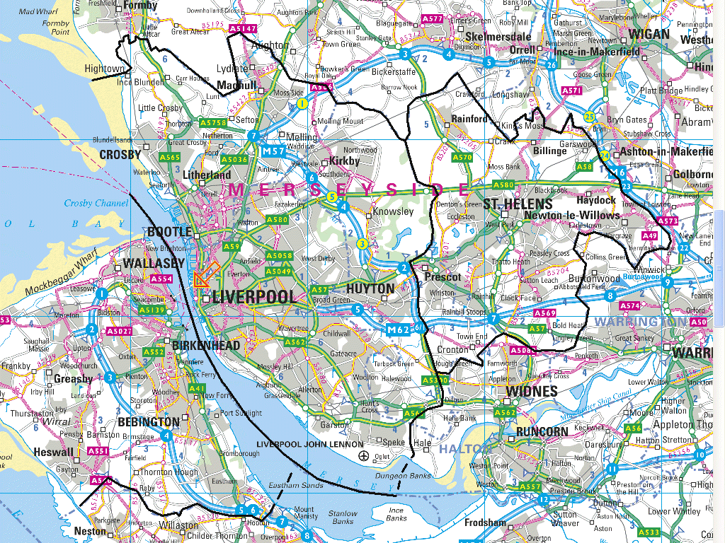
The proposed Liverpool and St. Helen's looks very close to mine:  |
|