cj
Socialist
These fragments I have shored against my ruins
Posts: 3,282 
|
Post by cj on Jan 28, 2021 19:16:55 GMT
I think Neath West's Broadland seat above is a little too long and thin for comfort. I've been trying to avoid shapes like that if possible. As David points out it is the boundary of the current seat but I do recall being pretty horrified by that when it was created ahead of the 2010 election. One way to avoid that is to go for my long-mooted plan to cross the boundary between Lowestoft and Great Yarmouth. Because Great Yarmouth is in quota it seems like a non-starter but as well as appealing to me because the areas added to Lowestoft are historically in Suffolk, the rest of the plan actually works quite well and sorts out the North Norfolk/Broadland boundary by hiving North Norfolk wards to Great Yarmouth instead  Although I have to concur that the Broadland seat was and is an abomination without focus, identity and in the case of most of it any Broads, the revanchist Suffolk proposal butchers any cohesion to a Great Yarmouth seat, the wards returned to their historic county still have economic, geographic and demographic link to the town of Yarmouth, indeed most of it is a contiguous sprawl of light industrial and housing estates these days and the wards in North Norfolk all have their focus northward towards North Walsham or even west to Norwich not south through poor road and non-existent public transport links. |
|
|
|
Post by Pete Whitehead on Jan 28, 2021 20:30:47 GMT
As I've said that isn't what I'm proposing because I know they aren't going to go for upsetting the arrangements in Great Yarmouth. This is an intellectual exercise to show what is possible if you did do that. My 'preferred' option (that is to say what I would propose were I to make a submission regarding this part of the region) is to link the area of the former Forest Heath district with the area around Thetford.
|
|
|
|
Post by Pete Whitehead on Jan 28, 2021 20:38:35 GMT
To be precise, this  |
|
|
|
Post by East Anglian Lefty on Jan 28, 2021 20:55:57 GMT
If you did want to improve Broadland, I think the easiest way would be for it to lose its current portion of North Norfolk and gain Hoveton & Tunstead ward plus St Benet's ward (or conceivably Worstead.) It would also serve to make the name fit significantly better.
|
|
|
|
Post by Pete Whitehead on Jan 28, 2021 21:07:58 GMT
If you did want to improve Broadland, I think the easiest way would be for it to lose its current portion of North Norfolk and gain Hoveton & Tunstead ward plus St Benet's ward (or conceivably Worstead.) It would also serve to make the name fit significantly better. I agree - I never understood why they didn't go for that option in the first place. And without wanting to reopen old arguments on this thread, this is the problem I have with some approaches to minimum change and 'established' boundaries because if a poor decision was made at one review it can get locked in for future ones. On my plan (because I've added Spixworth to Norwich North) it would have to take Stalham as well but that would be fine (probably worth adding Hickling too in that case). I might adopt that actually - it's at least worth making the case |
|
YL
Non-Aligned
Either Labour leaning or Lib Dem leaning but not sure which
Posts: 4,280
|
Post by YL on Jan 29, 2021 7:59:41 GMT
Alternate solution for Essex: 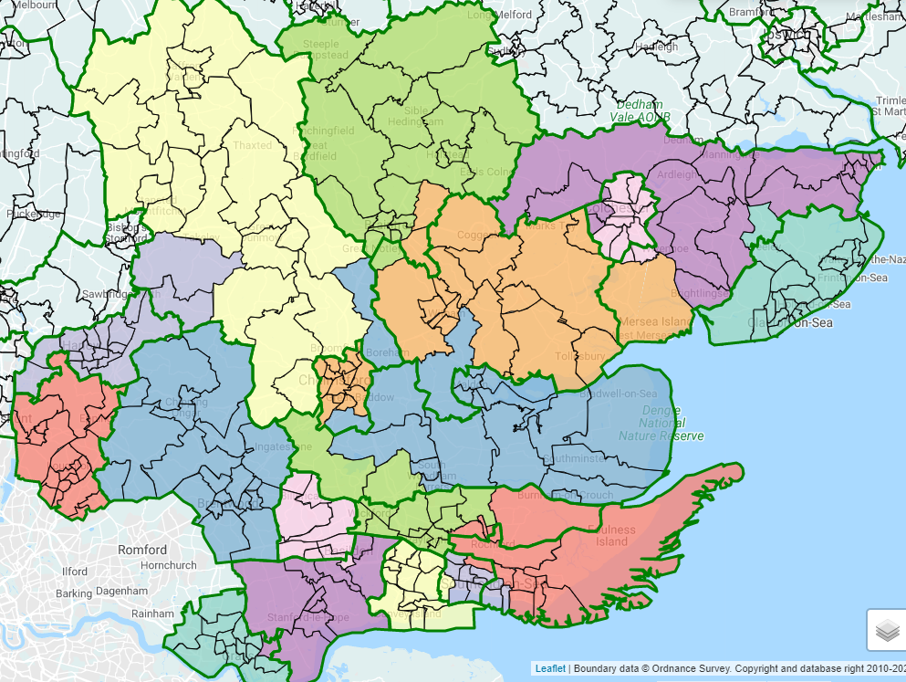 Saffron Walden 76748 Harlow 73479 Epping Forest 74553 Brentwood & Ongar 74937 Chelmsford 76454 Rayleigh & Wickford 75891 Basildon & Billericay 76993 S Basildon & E Thurrock 74936 Thurrock 73347 Castle Point 76569 Southend W 77016 Rochford & Southend E 72644 Maldon 75126 Witham 75706 Braintree 74871 Colchester 74520 Harwich & N Essex 74056 Clacton 70942 On the downside, Uttlesford district is split and Harlow now stretches across 3 districts. Putting Boreham in Maldon is also a little ugly. On the plus side, Epping Forest, Brentwood & Ongar, Braintree and Clacton are unchanged after re-alignment and disruption to most other seats is minimised. On a partisan level, I'm really not keen on Harlow adding any more electors than it absolutely has to, but on a practical level I'm finding it hard to see things here that the BCE would object to. For what it's worth (not a lot really TBH) this is very similar to what I currently have for Essex. The only differences that I can see are a different arrangement in Southend and that I expanded Harlow within Epping Forest district rather than into Uttlesford, and as a result put a couple of those annoying wards around Chelmsford into Brentwood & Ongar. |
|
|
|
Post by East Anglian Lefty on Jan 29, 2021 9:40:35 GMT
Yes, can definitely see a case for expanding Harlow into Epping Forest, but I figured leaving Epping Forest & Brentwood & Ongar unchanged is the sort of thing that would appeal to the BCE, and it also means that Chelmsford district is split between fewer constituencies. Plus those Uttlesford wards are as well connected to Harlow as most Epping Forest wards.
Then again, if we're talking about local connections then the pitchfork bait answer is to stick Sawbridgeworth in with Harlow and put the two Stansted wards plus Stort Valley in with Bishop Stortford. It'll never happen, but if you didn't know where the county boundary was then it'd be a pretty natural arrangement.
|
|
|
|
Post by Andrew_S on Feb 1, 2021 15:03:04 GMT
This works on the old numbers and the new ones (can provide if requested). Nothing we haven't seen before here but it works well  (Stevenage and NE Herts don't require any change to meet quota but I've moved Walkern only to equalise electorates a bit) Just noticed something odd. Tried to recreate Pete's map on Boundary Assistant (because I want to put everyone's plans in a spreadsheet and doing this is the easiest way to start the job). When I recreate his Broxbourne constituency I'm getting an electorate of 75,454 compared to 74,619 on this map from 5th January. Have the numbers been altered since then? |
|
|
|
Post by Pete Whitehead on Feb 1, 2021 15:07:34 GMT
This works on the old numbers and the new ones (can provide if requested). Nothing we haven't seen before here but it works well (Stevenage and NE Herts don't require any change to meet quota but I've moved Walkern only to equalise electorates a bit) Just noticed something odd. Tried to recreate Pete's map on Boundary Assistant (because I want to put everyone's plans in a spreadsheet and doing this is the easiest way to start the job). When I recreate his Broxbourne constituency I'm getting an electorate of 75,454 compared to 74,619 on this map from 5th January. Have the numbers been altered since then? Yes the numbers on that map are the old ones. I'd worked out the figures on the new numbers on a spreadsheet as this was after they had been released but before BA had been updated with them |
|
|
|
Post by Pete Whitehead on Feb 1, 2021 15:15:08 GMT
NB - if you want to put my plan on a spreadsheet you should know that I propose to keep Walkern in NE Herts and leave Stevenage unchanged. I will also make a case for moving Hertford Rural South into Welwyn Hatfield (on the old numbers it would have gone into Hertford & Stortford but on the new numbers it pushes that seat over quota)
|
|
jbp79
Non-Aligned
Posts: 21
|
Post by jbp79 on Mar 10, 2021 18:28:28 GMT
Looking at the Norfolk and Suffolk Sub-Region, I've drawn the below boundaries which seem to work well with the statutory principles of minimum change for many of the seats. Geographic and community boundaries have also been considered and followed as far as possible throughout. Of course, due to the size of the current Bury St Edmunds constituency, I have split this seat and created a new constituency labelled '6' on the map. The key shows this as 'Gipping Valley', but this seat could instead be called 'Stowmarket' (or something to that effect) as the seat focuses on the main settlement of Stowmarket. This proposal also creates one cross-border seat as the current West Suffolk constituency now crosses into Norfolk in the Thetford Forest area and loses the south of the current constituency to the new Bury St Edmunds conurbation. I have struggled somewhat with Norfolk, particularly South West Norfolk, as seen by the protrusion of the seat into Mid Norfolk. Any suggestions on better approaches to Norfolk would be appreciated. View Map on Google Drive (if anyone can tell me how to include an image in a post that would be great!) 1. Central Suffolk - 70,295. Yes 2. Suffolk Coastal - 72,955. Yes 3. Ipswich - 75,117. Yes 4. South Suffolk - 73,821. Yes 5. Waveney - 70,418. Yes 6. Gipping Valley (/Stowmarket) - 71,147. Yes 7. Bury St Edmunds - 73,698. Yes 8. Newmarket & Thetford Forest - 71,376. Yes 9. Broadland - 75,463. Yes 10. North Norfolk - 72,767. Yes 11. Great Yarmouth - 72,739. Yes 12. Mid Norfolk - 70,264. Yes 13. North West Norfolk - 70,536. Yes 14. Norwich North - 71,729. Yes 15. Norwich South - 73,301. Yes 16. South Norfolk - 76,528. Yes 17. South West Norfolk - 71,159. Yes |
|
|
|
Post by islington on Mar 10, 2021 18:54:46 GMT
Looking at the Norfolk and Suffolk Sub-Region, I've drawn the below boundaries which seem to work well with the statutory principles of minimum change for many of the seats. Geographic and community boundaries have also been considered and followed as far as possible throughout. Of course, due to the size of the current Bury St Edmunds constituency, I have split this seat and created a new constituency labelled '6' on the map. The key shows this as 'Gipping Valley', but this seat could instead be called 'Stowmarket' (or something to that effect) as the seat focuses on the main settlement of Stowmarket. This proposal also creates one cross-border seat as the current West Suffolk constituency now crosses into Norfolk in the Thetford Forest area and loses the south of the current constituency to the new Bury St Edmunds conurbation. I have struggled somewhat with Norfolk, particularly South West Norfolk, as seen by the protrusion of the seat into Mid Norfolk. Any suggestions on better approaches to Norfolk would be appreciated. View Map on Google Drive (if anyone can tell me how to include an image in a post that would be great!) 1. Central Suffolk - 70,295. Yes 2. Suffolk Coastal - 72,955. Yes 3. Ipswich - 75,117. Yes 4. South Suffolk - 73,821. Yes 5. Waveney - 70,418. Yes 6. Gipping Valley (/Stowmarket) - 71,147. Yes 7. Bury St Edmunds - 73,698. Yes 8. Newmarket & Thetford Forest - 71,376. Yes 9. Broadland - 75,463. Yes 10. North Norfolk - 72,767. Yes 11. Great Yarmouth - 72,739. Yes 12. Mid Norfolk - 70,264. Yes 13. North West Norfolk - 70,536. Yes 14. Norwich North - 71,729. Yes 15. Norwich South - 73,301. Yes 16. South Norfolk - 76,528. Yes 17. South West Norfolk - 71,159. Yes Welcome to the forum and congratulations on a fine debut post.
I've messaged you about including maps.
If you track back through this thread you'll find a number of Norfolk plans, but the more the merrier.
|
|
|
|
Post by greenhert on Mar 10, 2021 20:40:15 GMT
Looking at the Norfolk and Suffolk Sub-Region, I've drawn the below boundaries which seem to work well with the statutory principles of minimum change for many of the seats. Geographic and community boundaries have also been considered and followed as far as possible throughout. Of course, due to the size of the current Bury St Edmunds constituency, I have split this seat and created a new constituency labelled '6' on the map. The key shows this as 'Gipping Valley', but this seat could instead be called 'Stowmarket' (or something to that effect) as the seat focuses on the main settlement of Stowmarket. This proposal also creates one cross-border seat as the current West Suffolk constituency now crosses into Norfolk in the Thetford Forest area and loses the south of the current constituency to the new Bury St Edmunds conurbation. I have struggled somewhat with Norfolk, particularly South West Norfolk, as seen by the protrusion of the seat into Mid Norfolk. Any suggestions on better approaches to Norfolk would be appreciated. View Map on Google Drive (if anyone can tell me how to include an image in a post that would be great!) 1. Central Suffolk - 70,295. Yes 2. Suffolk Coastal - 72,955. Yes 3. Ipswich - 75,117. Yes 4. South Suffolk - 73,821. Yes 5. Waveney - 70,418. Yes 6. Gipping Valley (/Stowmarket) - 71,147. Yes 7. Bury St Edmunds - 73,698. Yes 8. Newmarket & Thetford Forest - 71,376. Yes 9. Broadland - 75,463. Yes 10. North Norfolk - 72,767. Yes 11. Great Yarmouth - 72,739. Yes 12. Mid Norfolk - 70,264. Yes 13. North West Norfolk - 70,536. Yes 14. Norwich North - 71,729. Yes 15. Norwich South - 73,301. Yes 16. South Norfolk - 76,528. Yes 17. South West Norfolk - 71,159. Yes This map also illustrates what is wrong with excessively sticking to minimum change when it comes to new boundaries. The current Central Suffolk & Ipswich North seat is not worth keeping, and there is no reason why the South Suffolk seat cannot now be entirely coterminous with Babergh. That redrawn Suffolk Coastal seat has pretty poor internal connections due to a removal of most of its western rural area. |
|
jbp79
Non-Aligned
Posts: 21
|
Post by jbp79 on Mar 10, 2021 23:21:01 GMT
Looking at the Norfolk and Suffolk Sub-Region, I've drawn the below boundaries which seem to work well with the statutory principles of minimum change for many of the seats. Geographic and community boundaries have also been considered and followed as far as possible throughout. Of course, due to the size of the current Bury St Edmunds constituency, I have split this seat and created a new constituency labelled '6' on the map. The key shows this as 'Gipping Valley', but this seat could instead be called 'Stowmarket' (or something to that effect) as the seat focuses on the main settlement of Stowmarket. This proposal also creates one cross-border seat as the current West Suffolk constituency now crosses into Norfolk in the Thetford Forest area and loses the south of the current constituency to the new Bury St Edmunds conurbation. I have struggled somewhat with Norfolk, particularly South West Norfolk, as seen by the protrusion of the seat into Mid Norfolk. Any suggestions on better approaches to Norfolk would be appreciated. View Map on Google Drive (if anyone can tell me how to include an image in a post that would be great!) 1. Central Suffolk - 70,295. Yes 2. Suffolk Coastal - 72,955. Yes 3. Ipswich - 75,117. Yes 4. South Suffolk - 73,821. Yes 5. Waveney - 70,418. Yes 6. Gipping Valley (/Stowmarket) - 71,147. Yes 7. Bury St Edmunds - 73,698. Yes 8. Newmarket & Thetford Forest - 71,376. Yes 9. Broadland - 75,463. Yes 10. North Norfolk - 72,767. Yes 11. Great Yarmouth - 72,739. Yes 12. Mid Norfolk - 70,264. Yes 13. North West Norfolk - 70,536. Yes 14. Norwich North - 71,729. Yes 15. Norwich South - 73,301. Yes 16. South Norfolk - 76,528. Yes 17. South West Norfolk - 71,159. Yes This map also illustrates what is wrong with excessively sticking to minimum change when it comes to new boundaries. The current Central Suffolk & Ipswich North seat is not worth keeping, and there is no reason why the South Suffolk seat cannot now be entirely coterminous with Babergh. That redrawn Suffolk Coastal seat has pretty poor internal connections due to a removal of most of its western rural area. It is probably difficult to visualise easily and I shall try to repost tomorrow with a map rather than a link to the map. Agreed about CSNI and under my proposal, the current central suffolk and north ipswich constituency is ‘replaced’ with the north ipswich part of the that constituency moving into a new stowmarket and north ipswich constituency (which I have called gipping valley given the location of the river gipping) and creating a constituency that runs along the a14 stowmarket to north ipswich housing and light industrial corridor. The bulk of the current CSNI seat - the central suffolk part - is then added to by wards on the landward side of the A12 from the suffolk coastal and Waveney constituencies to bring all three constituencies within electoral quota. This also fits the criteria of minimal change and using the current constituencies as the building blocks of the new ones. On the issue of the Suffolk coastal constituency, I am not sure I agree with you, as suffolk coastal is bordered by the a12 for most of its length, so is well connected from top to bottom by a major road, and also by rail to a large extent via the east suffolk train line. |
|
|
|
Post by East Anglian Lefty on Mar 11, 2021 9:33:01 GMT
I would say in terms of internal connections, it's Central Suffolk that's really bad, not Suffolk Coastal. Kesgrave is really out on a limb there, as its primary connections are west to Ipswich or east to Martlesham. It's only connected to the rest of the seat by quiet back roads. Swapping it for the northern part of your Suffolk Coastal represents communities much better, even if it does move a few extra electors.
You might also want to check some of the other plans in this thread which have similar overall orientations to yours, because if you look at those you'll see that you can easily eliminate three orphan wards (The Raynhams; Thurlton; what appears to be a split ward covering Clare) which also reduces the number of electors moved after reorientation to current ward boundaries. And if you do this it'll probably also eliminate Mid Norfolk's ugly arm to Watton.
|
|
jbp79
Non-Aligned
Posts: 21
|
Post by jbp79 on Mar 11, 2021 10:34:46 GMT
I'm reposting my map that I shared yesterday, now embedded in this post. Thanks to islington for your help. I thought it worth setting out the thinking behind my proposal in a little more detail, which I shall do at the bottom of this post.  1. Central Suffolk - 70,295. Yes 2. Suffolk Coastal - 72,955. Yes 3. Ipswich - 75,117. Yes 4. South Suffolk - 73,821. Yes 5. Waveney - 70,418. Yes 6. Gipping Valley (/Stowmarket) - 71,147. Yes 7. Bury St Edmunds - 73,698. Yes 8. Newmarket & Thetford Forest - 71,376. Yes 9. Broadland - 75,463. Yes 10. North Norfolk - 72,767. Yes 11. Great Yarmouth - 72,739. Yes 12. Mid Norfolk - 70,264. Yes 13. North West Norfolk - 70,536. Yes 14. Norwich North - 71,729. Yes 15. Norwich South - 73,301. Yes 16. South Norfolk - 76,528. Yes 17. South West Norfolk - 71,159. Yes In terms of further detail on my thinking here: a) I wanted to use the current constituencies as the primary building blocks of the new ones in line with the requirements of the legislation. b) Where possible, no changes were made to the constituencies within electoral quota in either Suffolk or Norfolk line with the legislation supporting minimum change. c) I recognised that the A11 corridor and the Thetford Forest area is the most natural point to create a cross county constituency between Norfolk and Suffolk. d) The current Bury St Edmunds constituency is very oversized and has two distinct halves. So a new constituency based around Stowmarket is logical and it is also logical to link Stowmarket with the North West Ipswich area along the A14 housing and industrial corridor to create a new constituency. e) Once the new Stowmarket and North Ipswich (which I have called Gipping Valley here) constituency is formed, it is logical for the bulk of the old Central Suffolk and North Ipswich constituency to be simply renamed Central Suffolk and for the excess electorate from the Suffolk Coastal and Waveney constituencies on the landward side of the A12 to be added to bring all constituencies within electoral quota. f) The new Bury St Edmunds seat, shorn of its Mid-Suffolk wards, picks up the wards in the south of the current West Suffolk constituency. g) Little change in Norfolk as several of the seats are already within electoral quota but I was a little stuck at the southern end of the Mid-Norfolk constituency with Saham Toney and All Saints & Wayland wards coming in from South West Norfolk and would value advice or thoughts from other posters. |
|
|
|
Post by islington on Mar 11, 2021 11:09:41 GMT
This reminds me that I never posted my Norfolk/Suffolk scheme, basically because it's very similar to a lot of others upthread.
 North West Norfolk - 70536. Unchanged except for ward realignment. North Norfolk - 74813. Broadland - 72988. A 'minimum change' option is available but it would have the effect of leaving Fakenham increasingly isolated at the western end of the seat, so instead I've shifted the whole Fakenham area into N Norfolk and kept this seat within range (and made it more compact) by adding Worstead, &c. Great Yarmouth - 70077. Coterminous with its district and unchanged.
Norwich North - 74086. Adds Thorpe Hamlet ward to get within range; I think this is better than what Pete Whitehead called the 'pixie hat' effect of adding Spixworth. Norwich South - 73515. This could have stayed unchanged, but the loss of Thorpe Hamlet means it has to add Old Costessey. But it's good to get the Costesseys together. South Norfolk - 70020. Loses its northwestern corner to get within range. Mid Norfolk - 75397. The current oversize seat shuffles eastward, gaining Hethersett, &c, from S Norfolk but losing territory, including Watton, Necton, on its opposite flank. South West Norfolk - 73054. Gains territory from Mid Norfolk but loses Thetford and adjacent areas. Thetford and Newmarket - 73423. The cross-border seat; and, importantly (in my view) for such a seat, firmly anchored by a large town on each side of the line. Although the configuration is very different, this seat takes over two-thirds of its electors from the existing W Suffolk and is best regarded as successor of that seat. Bury St Edmunds - 69780. The current seat is seriously oversize and loses all its territory in Mid Suffolk district and is completely realigned to take in Haverhill instead. South Suffolk - 71070. Modestly trimmed so as to coincide with Babergh district (but not adopting the name, please). Ipswich - 75117. Unchanged. Mid Suffolk - 70908. Probably best seen as the successor of the current horribly-named C Suffolk & Ipswich N, although actually taking less than half of its electorate from that seat. It takes Stowmarket and surrounding areas from Bury St Eds, and those to whom 'Mid' names are anathema might call it 'Stowmarket' instead. Woodbridge and Felixstowe - 75172. Really the successor to Suffolk Coastal but losing its entire northern area and picking up Kesgrave, &c. I'm very happy with this seat but I'm not claiming any originality for it because many other posters have had the same or very similar. (Indeed this comment might apply to this scheme as a whole.) Eye - 72939. The new seat, but it's a pleasure to see a fine old name revived. Lowestoft - 70418. The current Waveney seat, given a trim and a better name.
|
|
YL
Non-Aligned
Either Labour leaning or Lib Dem leaning but not sure which
Posts: 4,280
|
Post by YL on Mar 11, 2021 11:29:53 GMT
Looking at the Norfolk and Suffolk Sub-Region, I've drawn the below boundaries which seem to work well with the statutory principles of minimum change for many of the seats. Geographic and community boundaries have also been considered and followed as far as possible throughout. Of course, due to the size of the current Bury St Edmunds constituency, I have split this seat and created a new constituency labelled '6' on the map. The key shows this as 'Gipping Valley', but this seat could instead be called 'Stowmarket' (or something to that effect) as the seat focuses on the main settlement of Stowmarket. This proposal also creates one cross-border seat as the current West Suffolk constituency now crosses into Norfolk in the Thetford Forest area and loses the south of the current constituency to the new Bury St Edmunds conurbation. I have struggled somewhat with Norfolk, particularly South West Norfolk, as seen by the protrusion of the seat into Mid Norfolk. Any suggestions on better approaches to Norfolk would be appreciated. View Map on Google Drive (if anyone can tell me how to include an image in a post that would be great!) 1. Central Suffolk - 70,295. Yes 2. Suffolk Coastal - 72,955. Yes 3. Ipswich - 75,117. Yes 4. South Suffolk - 73,821. Yes 5. Waveney - 70,418. Yes 6. Gipping Valley (/Stowmarket) - 71,147. Yes 7. Bury St Edmunds - 73,698. Yes 8. Newmarket & Thetford Forest - 71,376. Yes 9. Broadland - 75,463. Yes 10. North Norfolk - 72,767. Yes 11. Great Yarmouth - 72,739. Yes 12. Mid Norfolk - 70,264. Yes 13. North West Norfolk - 70,536. Yes 14. Norwich North - 71,729. Yes 15. Norwich South - 73,301. Yes 16. South Norfolk - 76,528. Yes 17. South West Norfolk - 71,159. Yes Welcome to the forum. It looks from your map as if you might have been using old ward boundaries in some areas, which would explain why you still have some of the Clare etc. ward in South Suffolk; is that right? I was going to post my solution for SW Norfolk (adding the Watton area) but islington has just posted it for me; indeed I think his map is identical to the one I currently have except that I'd stuck with the minimal change approach to Broadland and North Norfolk. (I earlier posted a different plan, but I'm now persuaded that the border is best crossed in the Thetford area.) |
|
Adrian
Co-operative Party
Posts: 1,726
|
Post by Adrian on Mar 11, 2021 12:35:02 GMT
I've now gone through this region: ukelect.wordpress.com/tag/eastern-england/Norfolk and Cambridgeshire aren't too exciting. Herts and Beds: cross-border seat at Hitchin. Bushey North ward in Watford. An end to the current SW Herts seat. Essex and Suffolk: cross-border seat on the Stour estuary. Two Essex doughnuts. Rayleigh and Wickford split up. Maldon and Witham joined up. |
|
jbp79
Non-Aligned
Posts: 21
|
Post by jbp79 on Mar 11, 2021 17:23:21 GMT
Looking at the Norfolk and Suffolk Sub-Region, I've drawn the below boundaries which seem to work well with the statutory principles of minimum change for many of the seats. Geographic and community boundaries have also been considered and followed as far as possible throughout. Of course, due to the size of the current Bury St Edmunds constituency, I have split this seat and created a new constituency labelled '6' on the map. The key shows this as 'Gipping Valley', but this seat could instead be called 'Stowmarket' (or something to that effect) as the seat focuses on the main settlement of Stowmarket. This proposal also creates one cross-border seat as the current West Suffolk constituency now crosses into Norfolk in the Thetford Forest area and loses the south of the current constituency to the new Bury St Edmunds conurbation. I have struggled somewhat with Norfolk, particularly South West Norfolk, as seen by the protrusion of the seat into Mid Norfolk. Any suggestions on better approaches to Norfolk would be appreciated. View Map on Google Drive (if anyone can tell me how to include an image in a post that would be great!) 1. Central Suffolk - 70,295. Yes 2. Suffolk Coastal - 72,955. Yes 3. Ipswich - 75,117. Yes 4. South Suffolk - 73,821. Yes 5. Waveney - 70,418. Yes 6. Gipping Valley (/Stowmarket) - 71,147. Yes 7. Bury St Edmunds - 73,698. Yes 8. Newmarket & Thetford Forest - 71,376. Yes 9. Broadland - 75,463. Yes 10. North Norfolk - 72,767. Yes 11. Great Yarmouth - 72,739. Yes 12. Mid Norfolk - 70,264. Yes 13. North West Norfolk - 70,536. Yes 14. Norwich North - 71,729. Yes 15. Norwich South - 73,301. Yes 16. South Norfolk - 76,528. Yes 17. South West Norfolk - 71,159. Yes Welcome to the forum. It looks from your map as if you might have been using old ward boundaries in some areas, which would explain why you still have some of the Clare etc. ward in South Suffolk; is that right? I was going to post my solution for SW Norfolk (adding the Watton area) but islington has just posted it for me; indeed I think his map is identical to the one I currently have except that I'd stuck with the minimal change approach to Broadland and North Norfolk. (I earlier posted a different plan, but I'm now persuaded that the border is best crossed in the Thetford area.) Thanks for your welcome. I’m grateful to you for drawing my attention to the split at the Clare, Hundon & Kedington (CHK) ward. I have worked through this proposal on the data contained in the ONS dataset released on the 5th January which contains the electorate numbers for March 2020. This data shows CHK split between West Suffolk (3,476) and South Suffolk (2,751). Where some wards are split in the dataset with very small numbers on one side of the split, I have always included those with the majority of the ward within one constituency. For example, Minden ward is currently split with between Bury St Edmunds (4,285) and West Suffolk (1). The entirely of the Minden ward is now in the Bury St Edmunds constituency under this proposal, to illustrate my example here. I was under the impression that this data is accurate and the data that the Boundary Commission will be using as noted here: boundarycommissionforengland.independent.gov.uk/home/2023-review/Having said that, I have noted that some changes came into effect in May 2019 ( www.eadt.co.uk/news/suffolk-council-boundaries-2507706) and therefore I’ve included the whole of the CHK ward in the proposal now outlined below, which has not made a substantial difference to the numbers in the proposal and all seats still fall within the SER.  1. Central Suffolk - 70,295. Yes 2. Suffolk Coastal - 72,955. Yes 3. Ipswich - 75,117. Yes 4. South Suffolk – 71,070. Yes 5. Waveney - 70,418. Yes 6. Gipping Valley (/Stowmarket) - 71,147. Yes 7. Bury St Edmunds - 76,449. Yes 8. Newmarket & Thetford Forest - 71,376. Yes 9. Broadland - 75,463. Yes 10. North Norfolk - 72,767. Yes 11. Great Yarmouth - 72,739. Yes 12. Mid Norfolk - 70,264. Yes 13. North West Norfolk - 70,536. Yes 14. Norwich North - 71,729. Yes 15. Norwich South - 73,301. Yes 16. South Norfolk - 76,528. Yes 17. South West Norfolk - 71,159. Yes I’m hoping to try and tackle some of the suggestions others have raised for solutions in Norfolk soon! |
|